
Star-Telegram on continuing plans for the TEXRail commuter line. Looks like EPA EIS will take another year to complete, but negotiations are underway to secure needed right-of-way and funding. This article is also reprinted on the current APA www.planning.org website.
http://www.star-tele...s-chugging.html

1838 replies to this topic
#101

RD Milhollin
-

- Members
-

- 2,945 posts
Member
- Gender:Male
- Location:Las Vegas, NV
Posted 25 November 2012 - 01:06 PM
#102
Brian Luenser
-

- Members
-
- 3,083 posts
Skyscraper Member
- Gender:Male
- Location:Downtown Fort Worth
Posted 25 November 2012 - 06:37 PM
Really happy this rail line is progessing quicker than it seemed to be a year ago. I do kind of wish it was making a stop at the stockyards. But that's the thing about trains, if they make too many stops they are not very useful. I am getting excited about the whole project.
www.fortworthview.com
#103
Austin55
-

- Members
-
- 9,726 posts
Skyscraper Member
- Gender:Male
- Location:Near Southside
Posted 25 November 2012 - 07:07 PM
Fantastic news!
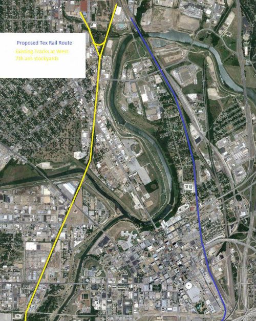
That is strange there wont be a stop at the stockyards, but I guess I can see why. Following the train tracks with aerial maps, I can't help but notice that the tracks that run out of the stockyards are the same ones that pass Montgomery Ward on 7th.
That is strange there wont be a stop at the stockyards, but I guess I can see why. Following the train tracks with aerial maps, I can't help but notice that the tracks that run out of the stockyards are the same ones that pass Montgomery Ward on 7th.
#104
Joshw
-

- Members
-
- 213 posts
Senior Member
- Location:North Fort Worth
Posted 26 November 2012 - 11:58 AM
I'm ready for it. This will be awesome when it gets underway!
#105
johnfwd
-
- Members
-
- 3,296 posts
Skyscraper Member
- Gender:Male
- Location:southwest
- Interests:Running, bicycling, bowling, nightclub life, science, technology.
Posted 27 November 2012 - 12:46 PM
It's always difficult to plan ahead and I, among others, would have liked a rail stop at the Stockyards. It's even more difficult to anticipate long-term transportation needs--e.g., at future commercial/residential developments in connection with the TRV, south of the Stockyards.
#106
Joshw
-
- Members
-
- 213 posts
Senior Member
- Location:North Fort Worth
Posted 27 November 2012 - 04:35 PM
I will imagine that the Stockyards will become more popular if the TRV gets off the ground, especially with how walkable they are wanting that area to be, it'd only make sense to have this infrastructure put together before they get that rolling.
#107
Austin55
-
- Members
-
- 9,726 posts
Skyscraper Member
- Gender:Male
- Location:Near Southside
Posted 27 November 2012 - 06:14 PM
I know next to nothing about rail and how it can be implemented and changed, but I since Tex Rail seems as if its being built on existing tracks, I wonder if they coule use these, (in yellow) they are literally in the stockyards and West 7th.
#108
JBB
-

- Members
-
- 7,442 posts
Skyscraper Member
- Gender:Male
- Location:Dirty suburbs
Posted 27 November 2012 - 09:37 PM
If the goal of TEX Rail (or commuter rail in general) is to get people off of freeways between population and employment centers, then I see little point in spending a lot of money to connect this line with the Stockyards since it is neither one.
#109
renamerusk
-

- Banned
-
- 7,662 posts
Skyscraper Member
- Gender:Male
- Location:Fort Worth South
Posted 27 November 2012 - 10:32 PM
Once again, the T is displaying that it has a culture of “turning a deaf ear to” the concerns of others outside of its internal chambers when it comes to how the T doggedly proceeds in the implementation of its own agenda; and this has never been so nakedly demonstrated by these excerpted remarks taken from a report in the Fort Worth Star-Telegram, 11/24/12:
….As TEX Rail/Cotton Belt edges closer to construction, here are some details and tension points that are coming into sharper focus:
.....The Stockyards: Grapevine Councilwoman Sharron Spencer is concerned that the T waited until this year to disclose that the trains won't stop near the Fort Worth Stockyards….. But she is disappointed that, according to an updated version of the environmental impact statement, riders will instead stop at a north Fort Worth station about a mile from the Stockyards and board shuttle buses for the last leg of the trip…."We were under the impression there would be a stop in proximity to the Stockyards," Spencer said during a recent TEX Rail meeting in Grapevine. ..We probably need to sit down and visit about that because it may be a very major issue."…In late 2006, Grapevine voters agreed to a 1-cent sales tax increase that included three-eighths of a cent for commuter rail. Since then, the T has collected $37.9 million from Grapevine merchants for the TEX Rail/Cotton Belt project....T officials said they understand the concerns but never intended to build a station within practical walking distance of the Stockyards..."Either way, the riders are going to have to get on a shuttle bus to get over there," T planning director Curvie Hawkins said……
Is there any doubt why the T continues to lose massive amounts of credibility with the public and other governmental organizations?
Keep Fort Worth folksy
#110
Russ Graham
-

- Members
-
- 510 posts
Elite Member
- Gender:Male
- Location:Baltimore
Posted 28 November 2012 - 07:47 AM
If the goal of TEX Rail (or commuter rail in general) is to get people off of freeways between population and employment centers, then I see little point in spending a lot of money to connect this line with the Stockyards since it is neither one.
"The goal" of TEX rail has never really been spelled out, but if I had a vote, it would have to include "regional connectivity" (other than just commuting) in some form. For instance, DFW Airport is neither a population or employment center - it's an intermodal connection. I don't see why you'd take major regional tourist destinations such as the Stockyards and Cultural District off the table. I seem to remember at one time there were two options, one that connected through downtown, vs a western leg something like what Austin55 has posted above. That decision was made with little or no public input, just like all other decisions about this project. It looks like at least the Grapevine City Council would rather connect to the Stockyards than Downtown FW, and they've chipped in $40 million, so you'd think they'd have some influence other than arguing back and forth in the newspaper.
(P.S. Austin55's route would allow train access to the TRV for Jeriat's new soccer stadium too...)
#111
AndyN
-

- Moderators
-
- 2,281 posts
Skyscraper Member
- Gender:Male
- Location:Downtown Fort Worth
Posted 28 November 2012 - 09:42 AM
Once again, the T is displaying that it has a culture of “turning a deaf ear to” the concerns of others outside of its internal chambers when it comes to how the T doggedly proceeds in the implementation of its own agenda; and this has never been so nakedly demonstrated by these excerpted remarks...
...Is there any doubt why the T continues to lose massive amounts of credibility with the public and other governmental organizations?
It's a matter of production and capability of doing it. As you know, ah, you go to war with the army you have---not the army you might want or wish to have at a later time
If the cost of putting a direct stop in to the Stockyards is important to you, are you willing to delay the start of operations by 5 years to pay for the additional costs? Will you complain that the board is not working fast enough? Will you complain that the board should be able to figure out someway to pay for an expensive new line with all the bells and whistles without having enough money? Clearly they are pretty apathetic and useless if they can't figure out how to make money spring from the ground to pay for this stuff.
Www.fortwortharchitecture.com
#112
Joshw
-
- Members
-
- 213 posts
Senior Member
- Location:North Fort Worth
Posted 28 November 2012 - 09:43 AM
Personally, if you make it where you can walk from the North Fort Worth station to the Stockyards, that'd be enough for me. Lit correctly, proper sidewalks/paths (not walking through a parking lot), I think many people would be fine with that in good weather. Especially during rodeos and other events, you are walking from the back-40 anyway. They need the bus for the elderly, those with kids, and during events. Perhaps something much like Molly the Trollybus.
#113
Doohickie
-

- Members
-
- 5,049 posts
Skyscraper Member
- Gender:Male
- Location:South Hills
Posted 28 November 2012 - 10:09 AM
To me the solution to the Stockyards situation is clear: Extend the Stockyards to the station. The Swift packing plant is being demolished; redevelop it to provide a tourist corridor along 23rd street that becomes a destination in itself, and serves as a gateway to the Exchange Ave. section of the Stockyards.
- Austin55 likes this
My blog: Doohickie
#114
downtowndweller
-

- Members
-
- 43 posts
Junior Member
- Location:76102
Posted 28 November 2012 - 11:28 AM
^I agree. For comparison's sake, Tarrant County Courthouse is a 0.9 mile walk from T&P Station. What is that, a 15 minute walk, tops? As long as people aren't walking through parking lots and areas without sidewalks, I don't see what the issue would be. Sounds like a great opportunity for some TOD with hotels, shops and housing.
- Brian Luenser likes this
#115
RD Milhollin
-
- Members
-
- 2,945 posts
Member
- Gender:Male
- Location:Las Vegas, NV
Posted 28 November 2012 - 11:36 AM
To me the solution to the Stockyards situation is clear: Extend the Stockyards to the station. The Swift packing plant is being demolished; redevelop it to provide a tourist corridor along 23rd street that becomes a destination in itself, and serves as a gateway to the Exchange Ave. section of the Stockyards.
Since there is no historic structure that will remain after the old plant is cleared away except for the old office building (formerly Spaghetti Warehouse, etc.) it might be a stretch to market this as a historic district. However the property the former killing plants sat on is owned in pretty large chunks, and they could be consolidated to provide the land for a significant mixed use "urban village" on the prominent hill overlooking the real historic district. Any developer able to pull this off would easily qualify for TIF status and no doubt public financing. They would also be able to work with the various agencies to bring the train into their development, an easy walk down to the historical district. But AndyN makes an important: don't let these sorts of future potential improvements to the plan hold up the implementation today.
#116
downtowndweller
-
- Members
-
- 43 posts
Junior Member
- Location:76102
Posted 28 November 2012 - 11:54 AM
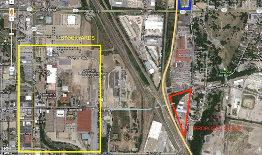
It would be really convenient if the FWST would include in their stories what I'm about to post. Oh well. Took me about 10 minutes to put this together:

Proposed Site #1 is the site where extensive chemical clean up is needed. It is obviously much closer to the Stockyards, but as the article states, the TEX Rail track will be constantly used by freight, subsequently blocking pedestrian and shuttle bus traffic on 23rd Street into the Stock Yards.

Proposed Site #2 is a little bit further than Site #1. Not sure how viable TOD is there.

Either way, the station wasn't going to be able to dump people directly into the Stockyards like Ms. Spencer would have liked.
Proposed Site #1 is the site where extensive chemical clean up is needed. It is obviously much closer to the Stockyards, but as the article states, the TEX Rail track will be constantly used by freight, subsequently blocking pedestrian and shuttle bus traffic on 23rd Street into the Stock Yards.
Proposed Site #2 is a little bit further than Site #1. Not sure how viable TOD is there.
Either way, the station wasn't going to be able to dump people directly into the Stockyards like Ms. Spencer would have liked.
- Brian Luenser likes this
#117
djold1
-

- Members
-
- 689 posts
Elite Member
- Gender:Male
- Location:76179
Posted 28 November 2012 - 07:44 PM
The destination/departure point for the TEX rail system is the T&P Station and the Intermodal terminal which host all rail lines and the buses. This is also the destination/departure point for the projected southwest line. There are no options on this. This was determined many years ago.
Fort Worth has heavy rail infrastructure from north to south (BNSF/UP) and east to west (UP) that boxes in the eastern quadrant of downtown. In addition the old Cotton Belt rail line operated by the Forth Worth & Western consumes some track space to the north east of the city. While a regional carrier, they are also busy. Historically these rail lines were where much of the wealth of the city was generated after 1876.
The maps in this thread show graphically the problem. Tex Rail will come in from the northeast through the rail yard that is just under I-35 where it passes over Long Avenue. A mile or so south west, the BNSF North Yard connection & the UP cut-off track turns due south toward downtown. They meld with the BNSF (Old Santa Fe) and the UP (Old Rock Island) lines that drop south from Saginaw then crossing NE 23rd and Decatur Road, over the triple truss bridges and then downtown.
For Tex Rail to stay on the east side of Fort Worth so that it can eventually get to the Intermodal Terminal, the tracks it uses MUST stay on the inside of this curve to the south and use one of the bridges that are in use now. There is no other way to get to the IT.
If you have never seen the junction of NE-23rd, Decatur Avenue and Samuels Avenue then you haven't seen a true disaster in the making. To go east on NE-23rd to Decatur Ave, the driver must cross three widely spaced sets of tracks more or less protected by lights and crossing gates, make an oblique turn north and hope that something doesn't hit the car. The area where the station is plotted is historically one of Fort Worth's finer chemical disaster areas having from the earliest times tanneries creosote plants and anything else bad you can imagine planted on the shores of the beautiful Trinity River and spewing fetid guck south toward Riverside and Dallas.
What about the rail line that shows on the map continuing southwest INTO the Stockyards area by crossing all three of the north/south lines at a diagonal near what was the old interlocker Tower #60? By extending East Exchange Avenue to the rail lines you would indeed have a good station point that was essentially in the Stockyards itself and which is what I think the Grapevine Tourist lines really wanted. This would be a couple of blocks north of where the rails cross NE-23rd just east of the old Swift brick wall. Both the Grapevine train and the FWWR freight trains run over these daily with considerable business.
The problem is that as this line leaves the Stockyards heading south, it turns to the west crossing North Main Street south of Northside drive and then angles across the West Fork on the old Frisco Bridge then runs along the river past Montgomery Plaza, through the park under the UP near I-30 and on down 8th Avenue toward Granbury. Not even close to the Intermodal or downtown Fort Worth in any way. So pretty useless for the purpose.
The point is.. That unless you want to build a totally new rail line, there often is limited availability for places like stations.
Pete Charlton
The Fort Worth Gazette blog
The Lost Antique Maps of Fort Worth on CDROM
Website: Antique Maps of Texas
Large format reproductions of original antique and vintage Texas & southwestern maps
#118
renamerusk
-
- Banned
-
- 7,662 posts
Skyscraper Member
- Gender:Male
- Location:Fort Worth South
Posted 28 November 2012 - 11:49 PM
If the cost of putting a direct stop in to the Stockyards is important to you, are you willing to delay the start of operations by 5 years to pay for the additional costs? Will you complain that the board is not working fast enough? Will you complain that the board should be able to figure out someway to pay for an expensive new line with all the bells and whistles without having enough money? Clearly they are pretty apathetic and useless if they can't figure out how to make money spring from the ground to pay for this stuff.
1. If the cost of putting a direct stop in to the Stockyards is important to you, are you willing to delay the start of operations by 5 years to pay for the additional costs?
Yes I am willing to delay the start of operations if a better product can result from a consensus of all the parties involved. It is my experience that haste often makes for waste; or that a penny saved is usually pound foolish.
There is a slew of published reports in the local media regarding the frustrations that both elected officials and the public by large with the direction of or lack of direction that the Fort Worth Transportation Authority is accused of; the latest being members of the City of Grapevine Council who must feel that they have been mislead somewhat by the T. Instead of viewing their concerns as just another complaint, I find that Grapevine has the right to question how they could have been led to believe something vastly different then what the T insists was never to be included in its plans.
One of the highest priorities of an organization should be safety. How is crossing several busy railroad crossings multiple times a day consider a safe and preferred option? What if a shuttle driver is having a bad day? What about a derailment? Should a shuttle proceed through a malfunction crossing bar? Both Grapevine and Fort Worth should be questioning the T about this decision; and the potential for great liability. And of course, Grapevine is all in because of the tourist industry between Grapevine and the Stockyards; for after all, let’s face it, most of Grapevine’s workforce commutes to and from Dallas.
2. Will you complain that the board is not working fast enough?
I would guess that is very unlikely that the members of the T board troll the Fort Worth Forum on a frequent bases; because I believe if it were the case that a member did, he or she would benefit enormously from the insight regularly posted herein. Already, the extension of Exchange Ave has been suggested; and would seem a no brainer; in fact, I go further and suggest the construction of a connector road and bridge between East Exchange Avenue and Brennan Avenue. See, if the T had real vision, it might have already approached the City of Fort Worthand the major Stockyard interests about just such a road project; you know, the approach that certain power brokers did not hesitate in taking to get Harley Avenue realigned. And yes had the T better planned for the safest way to connect the rail station to the Stockyards, then its hair raisings and problematic railroad crossing scheme and the justifiable concerns that have arisen could have been avoided. And yes, it may cost more but in the greater scheme of things, a safe and pedestrian friendly crossing would address everyone’s concerns. True, the T is on a mission to meet a deadline that has become tenuous because of many self afflicted wounds; but now as these latest concerns have become public, and more are bound to arise, I think a delay is quite probable; and for sure, the blame lies largely with the ineptness of the T.
3. Will you complain that the board should be able to figure out someway to pay for an expensive new line with all the bells and whistles without having enough money? Clearly they are pretty apathetic and useless if they can't figure out how to make money spring from the ground to pay for this stuff.
As for funding, approximate 28% is local, the remaining is Federal and State funding which has already been allocated and is awaiting the process of securing. There is a pathetic strain of nay-saying going around; particularly in Red Tarrant County that we cannot afford to build for the future because we are broke. I recommend a visit to Dallas where one can determine for oneself whether Dallas feels the same constraints when it comes to designing and building the cutting edge infrastructure it wants for its future.
And yes, I agree, that the T is pretty apathetic and useless; and that is what I have been saying for a very long time.
Keep Fort Worth folksy
#119
Doohickie
-
- Members
-
- 5,049 posts
Skyscraper Member
- Gender:Male
- Location:South Hills
Posted 29 November 2012 - 09:16 AM
How about extending E. Exchange as a pedestrian walk from the XTO Energy (old Swift/Spaghetti Warehouse), then building a bridge/tunnel across the tracks to the new station? Build a hotel at the western terminus of the bridge, make it a covered bridge over to the station, then walk from the train station into the hotel, and out onto Exchange. In this diagram, the bridge is shown as the dotted line. If the bridge is too long, maybe make it an elevated tram like the ones that carry passengers from ticketing areas to boarding gates at some airports.
It's less than a half mile from the station to the east end of the Stockyards. And that would kickstart redevelopment of that area. There aren't old buildings there, so maybe go with more traditional tourist trap stuff, like a Rainforest Cafe, Ripley's Believe it or Not, etc. I bet you'd see overall tourism at the Stockyards increase significantly.
It's less than a half mile from the station to the east end of the Stockyards. And that would kickstart redevelopment of that area. There aren't old buildings there, so maybe go with more traditional tourist trap stuff, like a Rainforest Cafe, Ripley's Believe it or Not, etc. I bet you'd see overall tourism at the Stockyards increase significantly.
My blog: Doohickie
#120
Joshw
-
- Members
-
- 213 posts
Senior Member
- Location:North Fort Worth
Posted 29 November 2012 - 10:18 AM
Regarding the NE 23rd ST/ Decatur Ave site, is that the company that is there still saying they won't give up their land? Or is that still under negotiation?
#121
Russ Graham
-
- Members
-
- 510 posts
Elite Member
- Gender:Male
- Location:Baltimore
Posted 29 November 2012 - 03:16 PM
....The destination/departure point for the TEX rail system is the T&P Station and the Intermodal terminal which host all rail lines and the buses. This is also the destination/departure point for the projected southwest line. There are no options on this. This was determined many years ago.
What about the rail line that shows on the map continuing southwest INTO the Stockyards area by crossing all three of the north/south lines at a diagonal near what was the old interlocker Tower #60? By extending East Exchange Avenue to the rail lines you would indeed have a good station point that was essentially in the Stockyards itself and which is what I think the Grapevine Tourist lines really wanted. This would be a couple of blocks north of where the rails cross NE-23rd just east of the old Swift brick wall. Both the Grapevine train and the FWWR freight trains run over these daily with considerable business.
The problem is that as this line leaves the Stockyards heading south, it turns to the west crossing North Main Street south of Northside drive and then angles across the West Fork on the old Frisco Bridge then runs along the river past Montgomery Plaza, through the park under the UP near I-30 and on down 8th Avenue toward Granbury. Not even close to the Intermodal or downtown Fort Worth in any way. So pretty useless for the purpose.
You make a pretty good case for the western line - as you say it's already in use. And that's the line that connects to the Mistletoe station. I don't know why connecting to downtown has to be considered "set in stone" when there are pretty good arguments for connecting with west Ft Worth instead. It's apparent that at least Grapevine prefers connecting to the Stockyards, future TRV, Montgomery Plaza, and the Medical Dist. over the central business district. I see the advantages of connecting to the ITC, but there's always the possibility of a third, rail-based connector from Montgomery Plaza to the ITC... (not sure what form that would take, but it would run along the street).
By the way, how is TEX going to get from the ITC to the Mistletoe station?
#122
RD Milhollin
-
- Members
-
- 2,945 posts
Member
- Gender:Male
- Location:Las Vegas, NV
Posted 29 November 2012 - 07:38 PM
By the way, how is TEX going to get from the ITC to the Mistletoe station?
Check out this video tour animation:
http://www.texrail.com/default.asp
Though some of the details have changed (like the preferred locate of the Medical District station) you can see the route from Southside into downtown
#123
Electricron
-

- Members
-
- 769 posts
Elite Member
Posted 29 November 2012 - 07:48 PM
I believe tourists will be better satisfied with Grapevine's Vintage Railroad steam powered train that runs directly to the Stockyards. It's a true tourist railroad experience. So, I believe it is a good thing the Cotton Belt will not have a station stop in the Stockyards.
The rail line west of downtown Fort Worth that runs through Trinity Park belongs to the FWWR. It was amongst the alternatives considered prior to selecting the preferred route through downtown using UP and TRE trackage. The FWWR route wouldn't have transfers to both Amtrak and TRE trains, nor directly served downtown Fort Worth, so it is obvious why it lost.
Either 23rd or 28th Street will make great locations for a train station in north Fort Worth. I believe 28th Street location would be better for several reasons. 28th Street is a through arterial street crossing under or over all the tracks, with sidewalks that also do. There's no need to build much more or spend a small fortune for brand new bridges and underpasses that would have to be built almost the entire way from 23rd Street since every railroad crossing is at grade today. What Fort Worth would have to do is build a new entrance to the stockyards from 28th Street, something I believe needs to be done anyways even if the commuter rail isn't built. A new entrance from the north will allow the Stockyard pens to redevelop quicker. A cost the rail agency shouldn't have to finance.
As far as distance is concerned, from 23rd Street Station location to the turntable in the Stockyards (a common place of reference I chose), it's 4600 feet, from 28th Street Station it's 4800 feet (as I expect the sidewalks to be laid out). The distances are very close anyways (within 200 feet), the precise layout and route taken by streets and sidwalks could add 600 feet to either route (two blocks in total, ie walking west and additional block and having to walk that same block back east further north or south). At nearly a mile from either station location anyways, most tourists would rather take a shuttle bus if one were available. And most tourists would rather ride behind the steam locomotive directly into the Stockyards from Grapevine.
#124
renamerusk
-
- Banned
-
- 7,662 posts
Skyscraper Member
- Gender:Male
- Location:Fort Worth South
Posted 30 November 2012 - 12:09 AM
How about extending E. Exchange as a pedestrian walk......build[ing] a bridge/tunnel across the tracks to the new station?....
And that would kickstart redevelopment of that area....I bet you'd see overall tourism at the Stockyards increase significantly.
Agree, agree, and agree! Yours is the sort of brainstorming that should have been in place at the T from the beginning of this project. I predict that Mr. Steve Murrin and the Stockyards TIF will be on this or something very like this in short time.
Keep Fort Worth folksy
#125
Electricron
-
- Members
-
- 769 posts
Elite Member
Posted 30 November 2012 - 02:48 AM
Agree, agree, and agree! Yours is the sort of brainstorming that should have been in place at the T from the beginning of this project. I predict that Mr. Steve Murrin and the Stockyards TIF will be on this or something very like this in short time.
Keep Fort Worth folksy!
Who's going to build and pay for that pedestrian bridge?
You'll have to bridge over 9 tracks in total, over four different railroads companies tracks, over a distance of 700 feet.
Do you remember the headaches when Fort Worth wanted to build the new turnpike over the UP tracks?
Quadruple that for this location.....UP, BNSF, FWWR, and DART are the owners of these tracks, and everyone will be asking for an arm and a leg.
The only thing great about this proposal is that the distance needed to walk to the turntable is 2400 feet, 2200 feet shorter than before. It would reduce the distance in half.
#126
Doohickie
-
- Members
-
- 5,049 posts
Skyscraper Member
- Gender:Male
- Location:South Hills
Posted 30 November 2012 - 12:03 PM
I don't have all the answers and frankly I don't expect any kind of implementation along those lines, but it makes for interesting conversation. Have you ever been to the Crystal City area of Arlington, VA? They have over a mile of subterranean tunnels connecting dozens of buildings, including tunnels under a major freeway and rail tracks. The tunnel is lined with shops and restaurants. I'm not saying that the Stockyards = Crystal City, but any suggestions that make entry to the Stockyards easier should be of interest to all business owners in that area. They've done a wonderful job of remodeling the old building along Exchange Street, but more modern infrastructure would make the Stockyards more accessible. Too bad a Bass family member or one of the other civic leaders hasn't taken an interest in the Stockyards. So much potential. It's being tapped, but there's more potential there. Maybe as the area where the old packing plants were is redeveloped, some of this will happen.
My blog: Doohickie
#127
renamerusk
-
- Banned
-
- 7,662 posts
Skyscraper Member
- Gender:Male
- Location:Fort Worth South
Posted 30 November 2012 - 08:37 PM
Who's going to build and pay for that pedestrian bridge?
Mostly you and I locally along with state and federal funds. Time after time, a majority of voters regularly approve at the ballot funding for new street and road through bond elections. The Fort Worth Stockyards is regarded by the citizens as one of the really special places in town; and I confident that the prospect of new businesses and more employment in the Stockyards will be extremely popular.
We are not Greece!
#128
Electricron
-
- Members
-
- 769 posts
Elite Member
Posted 01 December 2012 - 01:30 AM
Who's going to build and pay for that pedestrian bridge?
Mostly you and I locally along with state and federal funds. Time after time, a majority of voters regularly approve at the ballot funding for new street and road through bond elections. The Fort Worth Stockyards is regarded by the citizens as one of the really special places in town; and I confident that the prospect of new businesses and more employment in the Stockyards will be extremely popular.
We are not Greece!
You're assuming that 23rd Street is the preferred station location, overlooking the fact that 28th Street will be for the very reasons I stated earlier. No one will need to build a 700 feet long pedestrian tunnel or bridge because the train station will not be built there.
Few tourists are going to want to walk 2500 feet, fewer will want to walk 5000 feet, so having a pedestrian tunnel or bridge is mute. FWTA will just run a local bus whether it's funded directly by them, or indirectly by Stockyard businesses.
#129
renamerusk
-
- Banned
-
- 7,662 posts
Skyscraper Member
- Gender:Male
- Location:Fort Worth South
Posted 01 December 2012 - 05:15 PM
You're assuming that 23rd Street is the preferred station location....No one will need to build a 700 feet long pedestrian tunnel or bridge because the train station will not be built there.....Few tourists are going to want to walk 2500 feet, fewer will want to walk 5000 feet, so having a pedestrian tunnel or bridge is mute.
No, I am not assuming anything about 23rd Street as the two site locations in question both front Decatur Avenue. 23rd Street ends at the confluence of Samuels and Decatur Avenues; and at most is relevant only in that it is in the vicinity of the Stockyards. My preferred site location is the southernmost location which is due east of the old Swift Packing site as illustrated in Doohickie's post.
How did you arrived at a distance of 2500 or 5000 feet? I am suspicious, but even if that were the case, consider this: the Grapevine Old Main Street Tourist District, from Wall Street at the north end and to the rail station at the south end, is equal or greater than 2500 feet in length and that thousands of tourists and visitors walk that distance each year during Grapevine’s Annual GrapeFest: or for instance, the distance from the Tarrant County Courthouse to the Fort Worth Water Gardens is 2500-2800 feet. I have yet to hear someone complain about walking the length of either distances.
The suggestion for a tunnel was not my suggestion. I suggested a road/bridge to connect East Exchange Avenue to Brennan Avenue with an entrance if need be at a newly designed Exchange/Brennan Avenue – Decatur Ave intersection with possible funding by either a bond election or a TIF. For my two cents, the T should consider partnering with the Fort Worth/Stockyards to construct a cultural district-like garage in the Niles City Blvd/23rd Street area; but that would require the T seeking input from outside; and as it always seems, the T prefers to make of its mind up in-house and sticks with its decision to the end.
As for the 28th Street location that you seem to prefer, the Decatur Avenue and 28th Street intersection has historically been the site of flash flooding after heavy rains; and the tracks crossing 28th Street are above grade along Decatur Avenue. Two things that disadvantages the 28th Street site in my view.
Keep Fort Worth folksy
#130
Electricron
-
- Members
-
- 769 posts
Elite Member
Posted 02 December 2012 - 02:29 AM
I use the tools menu in Google Earth to find those distances in feet, using path and following existing streets instead of a direct line.How did you arrived at a distance of 2500 or 5000 feet? I am suspicious, but even if that were the case, consider this: the Grapevine Old Main Street Tourist District, from Wall Street at the north end and to the rail station at the south end, is equal or greater than 2500 feet in length and that thousands of tourists and visitors walk that distance each year during Grapevine’s Annual GrapeFest: or for instance, the distance from the Tarrant County Courthouse to the Fort Worth Water Gardens is 2500-2800 feet. I have yet to hear someone complain about walking the length of either distances.
You're assuming that 23rd Street is the preferred station location....No one will need to build a 700 feet long pedestrian tunnel or bridge because the train station will not be built there.....Few tourists are going to want to walk 2500 feet, fewer will want to walk 5000 feet, so having a pedestrian tunnel or bridge is mute.
I suggested a road/bridge to connect East Exchange Avenue to Brennan Avenue with an entrance if need be at a newly designed Exchange/Brennan Avenue – Decatur Ave intersection with possible funding by either a bond election or a TIF.
As for the 28th Street location that you seem to prefer, the Decatur Avenue and 28th Street intersection has historically been the site of flash flooding after heavy rains; and the tracks crossing 28th Street are above grade along Decatur Avenue. Two things that disadvantages the 28th Street site in my view.
The creek that floods is to the east of Decatur Road, the tracks and the sidewalk are to the west of Decatur Road.
Someone will have to pay for a 900 foot long bridge to connect Exchange with Brennan Avenues. That expense should be the city's responsibility, not FWTA. The city has had ample opportunity to do the past 100 years and failed to do so, why do you think they will now?
Water Gardens to Tarrant County Courthouse is 3600 feet along Houston Street. Convention Center to Tarrant County Courthouse is 2500 feet along Main Street. Both Houston and Main Street have dozens of shops visitors can srop in and take a respite along the walk. 23rd Street to the turntable in the Stockyards doesn't. There will be a hill to climb at the Stockyards, there's no hill in downtown Fort Worth to traverse. It's two different walks altogether.
#131
renamerusk
-
- Banned
-
- 7,662 posts
Skyscraper Member
- Gender:Male
- Location:Fort Worth South
Posted 02 December 2012 - 11:58 PM
….following existing streets instead of a direct line….The creek that floods is to the east of Decatur Road….Someone will have to pay for a 900 foot long bridge to connect Exchange with Brennan Avenues. That expense should be the city's responsibility, not FWTA….. Both Houston and Main Street have dozens of shops visitors can srop in and take a respite along the walk…There will be a hill to climb at the Stockyards.
1 - Google is a great tool, but it is not as great a tool as real life observation and knowledge of an area so that there are times when relying upon its application can be inaccurate.
2 - The flash flooding occurs at the intersection of Decatur and 28th Streets and will all but prevent vehicular traffic in and out of that particular station; and is designated as one of the critical flashing flood spots in the city as reported by WFAA (2010).
3 - Street and Bridge Projects are typically funded by voter approved bond programs.
My guess is that the design of a road and bridge to accomplish this would not require an extraordinary fete of engineering, probably a span no greater than the East 1st bridge over the TRE in Riverside. Building the prerequisite public infrastructure and encouraging the development of new retail and tourist attractions is what I and some of the bloggers (#113,#115) here have been advocating and are just what you, yourself have now cited as the reason for success and ease of walking along the Houston/Main Street corridors. Given all this, one can hope that the Stockyards will now, better late than never, cease upon the opportunity to encompass the North Side station into its master plan; and that an exciting project will be developed through their effort.
What is more to the issue about the North Side Station is how the FWTA has handled the matter. It has become increasingly more difficult for some of us in the public and some of our elected officials to have complete confidence in the agency’s transparency. There now appears, rightly or wrongly, the sense that the lines of communication between itself and the local governments in its service areas are strained. In this particular instance, the need for critical coordination to establish the goals agreeable to all parties seemed non existent or as one FWTA official so pointedly put it in an attempt to downplay the negative public reaction: [paraphrasing] We (FWTA) never intended on connecting to the Stockyards; and anyway, there will be shuttle bussing. The FWTA may have legitimate reasons for arriving at the decisions that it takes, but wasting its resources by designating Decatur/28th Street as a potential site demonstrates a lack of due diligence; and keeping your most important partners in the dark is artless.
FYI Most critical flash flooding points in the city:
http://www.wfaa.com/...-143370876.html
#132
Doohickie
-
- Members
-
- 5,049 posts
Skyscraper Member
- Gender:Male
- Location:South Hills
Posted 03 December 2012 - 10:53 AM
Both Houston and Main Street have dozens of shops visitors can srop in and take a respite along the walk. 23rd Street to the turntable in the Stockyards doesn't.
I think no matter what route people need to use to get from a new train station to the Stockyards, the route probably will/could/should be populated with tourist friendly business fronts. Think of all the stuff that surrounds Alamo Plaza in San Antonio. There are several museums, restaurants, etc., that take advantage of the foot traffic around the Alamo. If you have a designated route from the train station to the historic Stockyards district, it would only make sense to make that route part of the destination by populating it with those kinds of tourist-trappy businesses. It hasn't ruined the Alamo; it won't ruin the Stockyards. The big draw, if you do it right, is to keep people in climate controlled walkways while they walk over to the Stockyards. Cool them and the hike won't be near as bad. If you make 23rd Street the point of entry, there is already some amount of bicycle traffic that gets off the trail at 23rd St. to get to the Stockyards. I very rarely used that route, but since I've started riding a bike I've ridden it dozens of times with different groups.
My blog: Doohickie
#133
Russ Graham
-
- Members
-
- 510 posts
Elite Member
- Gender:Male
- Location:Baltimore
Posted 03 December 2012 - 01:43 PM
By the way, how is TEX going to get from the ITC to the Mistletoe station?
Check out this video tour animation:
http://www.texrail.com/default.asp
Though some of the details have changed (like the preferred locate of the Medical District station) you can see the route from Southside into downtown
I can't quite get my answer from that animation, it moves too fast for the details (or maybe I'm just slow). The north/south line that will connect to the mistletoe station is currently grade separated from the east-west line south of the freeway (I believe this is the UP line). Somehow TEX is planning on routing from one to the other; my question is, how will this be done? (specifically will a future possible extension of the system to include a Montgomery Plaza station remain viable?) It looks like the rail will have to cut off part of the parking lot of Baylor Surgical Hospital. http://goo.gl/maps/sOc76.
There also appears to be an abandoned rail ROW adjacent to 11th ave, that eventually links back up with what I think is the planned TEX route at Arlington Ave.
so my questions are, 1) which one is the actual planned TEX route, and 2) has "that other" ROW along 11th been ruled out for some reason, and 3) if so, can somebody give me some insight as to why.
Thanks!
#134
RD Milhollin
-
- Members
-
- 2,945 posts
Member
- Gender:Male
- Location:Las Vegas, NV
Posted 03 December 2012 - 03:00 PM
Russ Graham
Check out the presentation at this link
https://www.commentm...resentation.pdf
and go to page 20. you can see that the station planned for the Medical District is located on the existing FWWR right of way, the western of the two you referenced. The ROW adjacent to 11th Av appears to be abandoned; some parking lot construction has already taken place in that space. "Why" is another question and might have been a good one to have posed to the project managers at the recent meetings in November. Just a guess: The ROW wasn't available.
At the top (north edge) of the page 20 map you can see the projected approximate route of the TEXRail line(red) connecting the FWWR (purple) to UP (orange) tracks. There is going to be some grade change involved, evidenced by the fill shown outlined in blue on the map. Whether provisions in the planning would allow a ramp to be constructed on same grade change to connect the TEXRail line coming from Downtown to go northbound on the FWWR tracks in the future would have been another good question for the planners.
#135
renamerusk
-
- Banned
-
- 7,662 posts
Skyscraper Member
- Gender:Male
- Location:Fort Worth South
Posted 03 December 2012 - 03:17 PM
....23rd Street to the turntable in the Stockyards doesn't.
...If you make 23rd Street the point of entry, there is already some amount of bicycle traffic that gets off the trail at 23rd St. to get to the Stockyards....
I beg for some clarification as I have always believed that 23rd Street ended at the joining of Samuels Avenue and Decatur Avenue. If this is true, then neither the site of the proposed North Side Tex Rail Station platform cannot front or even straddle 23rd Street if it is to be along the existing rail line; can someone confirm whether this is factual or not?
Keep Fort Worth folksy
#136
Russ Graham
-
- Members
-
- 510 posts
Elite Member
- Gender:Male
- Location:Baltimore
Posted 03 December 2012 - 03:35 PM
Check out the presentation at this link
https://www.commentm...resentation.pdf
At the top (north edge) of the page 20 map you can see the projected approximate route of the TEXRail line(red) connecting the FWWR (purple) to UP (orange) tracks. There is going to be some grade change involved, evidenced by the fill shown outlined in blue on the map. Whether provisions in the planning would allow a ramp to be constructed on same grade change to connect the TEXRail line coming from Downtown to go northbound on the FWWR tracks in the future would have been another good question for the planners.
If I'm reading that right, it looks like it swings to the north under the future Chisholm Trail & merges with the FWWR before at the lower grade before crossing under the UP line. (right?)
#137
RD Milhollin
-
- Members
-
- 2,945 posts
Member
- Gender:Male
- Location:Las Vegas, NV
Posted 03 December 2012 - 03:49 PM
Right
#138
RD Milhollin
-
- Members
-
- 2,945 posts
Member
- Gender:Male
- Location:Las Vegas, NV
Posted 03 December 2012 - 03:57 PM
....23rd Street to the turntable in the Stockyards doesn't.
...If you make 23rd Street the point of entry, there is already some amount of bicycle traffic that gets off the trail at 23rd St. to get to the Stockyards....
I beg for some clarification as I have always believed that 23rd Street ended at the joining of Samuels Avenue and Decatur Avenue. If this is true, then neither the site of the proposed North Side Tex Rail Station platform cannot front or even straddle 23rd Street if it is to be along the existing rail line; can someone confirm whether this is factual or not?
Keep Fort Worth folksy
Look at page 21 of this map for clarification:
https://www.commentm...resentation.pdf
but note that the 23rd St. site is listed as being replaced by the one on 28th St.
#139
Electricron
-
- Members
-
- 769 posts
Elite Member
Posted 03 December 2012 - 04:10 PM
Main Street is the main entrance into the Stockyards today, and there aren't that many tourist friendly fronts today on Main Street.I think no matter what route people need to use to get from a new train station to the Stockyards, the route probably will/could/should be populated with tourist friendly business fronts.
Why do you think there will be more between a future train station and the Stockyards in the future, considering the train headways are projected to be every half hour to an hour? There just will not be as much traffic as you assume, ever!
As for where the line will be, read the "draft" Environmental Impact Statement. The FWTA is presently answering earlier responses and questions, writing the "final". Until the "final" has been issued and approved by the FTA, changes can be made without FWTA having to do a new EIS. That's why precise station locations are being set now.
Once the "final" EIS is approved and release, the specifics you're wanting answers to will be answered. That's also the time when the project is eligible to receive FTA "New Starts" funding - assuming it qualifies for it.
"Draft" EIS can be found at
http://www.texrail.c...dy.asp?area=eis
All the alternatives being considered are listed within it. Read it!
The "Draft" EIS has been out for public viewing since November 2008 (over 4 years ago).
I agree with those who have stated it's taken FWTA far too long to get a "Final" EIS approved.
DART rarely takes over a year between "draft" and "final".
But DART hasn't had to run rail lines over freight railroad owned corridors in the past, every DART line runs over city owned or DART owned row. FWTA is negotiating with several freight railroad companies, as well with DART. It's hard to get all of them to agree.
- djold1 likes this
#140
renamerusk
-
- Banned
-
- 7,662 posts
Skyscraper Member
- Gender:Male
- Location:Fort Worth South
Posted 03 December 2012 - 06:29 PM
....Main Street is the main entrance into the Stockyards today, and there aren't that many tourist friendly fronts today on Main Street.....Why do you think there will be more between a future train station and the Stockyards in the future, considering the train headways are projected to be every half hour to an hour? There just will not be as much traffic as you assume, ever!
Your description of Main Street is dubious and can be easily dissected and is not really relevant to the issue since the extension of East Exchange Street towards the Decatur Avenue/Neal/Brennan area is being suggested by me and others.
It has been shown that the energy generated by transit centers can be the catalyst for new development near the lines; and it is not inconceivable that developers hope to capitalize on this kind of energy by filling in the area that was previous occupied by the Swift Packing Co. with additional new retail and residential units once the prerequisite infrastructure is in place.
Given this proven economic model, why do you not think that there can be new development within the perimeter of the Stockyards after a rail station opens in the vicinity?
Keep Fort Worth folksy
#141
renamerusk
-
- Banned
-
- 7,662 posts
Skyscraper Member
- Gender:Male
- Location:Fort Worth South
Posted 03 December 2012 - 06:53 PM
...I have always believed that 23rd Street ended at the joining of Samuels Avenue and Decatur Avenue.
but note that the 23rd St. site is listed as being replaced by the one on 28th St.
Its just a fine point, but according to a Mapsco printed in 1998, NE 23rd Street comes to an end at the juncture of Samuels Avenue and Decatur Avenue. Labeling one possible site as being on 23rd Street is disorienting when in fact the track in question travels east of Samuels Avenue and do not ever cross 23rd Street. I hard to, but it is very possible that the FWTA has given little attention to this fault in their surveys; and if this is the case, then it is yet another instance of the sloppiness that is endemic to its culture. Using Google Maps is less effective than actually visiting the affected area. It might be helpful if FWTA or whoever is responsible for the display can be more exacting when labeling the site locations for the betterment of the public's understanding.
Keep Fort Worth folksy
#142
Electricron
-
- Members
-
- 769 posts
Elite Member
Posted 04 December 2012 - 12:53 AM
It has been shown that the energy generated by transit centers can be the catalyst for new development near the lines; and it is not inconceivable that developers hope to capitalize on this kind of energy by filling in the area that was previous occupied by the Swift Packing Co. with additional new retail and residential units once the prerequisite infrastructure is in place.
Given this proven economic model, why do you not think that there can be new development within the perimeter of the Stockyards after a rail station opens in the vicinity?
Keep Fort Worth folksy
How long has the Armour meat packing plant property remained barren and undeveloped?
Why do you believe the Swift meat packing plant property will have better results redeveloping?
What's been missing in the stockyard area as been city streets, with water and sewer mains, and electric lines every 300 to 400 feet apart. Streets 900 feet apart don't help redeveloping efforts much. A train will help some, but not nearly as much as city streets in some sort of a grid pattern.
The first items developers complete in any new neighborhood are streets and utilities. Without them, the new neighborhood will not rise.
#143
renamerusk
-
- Banned
-
- 7,662 posts
Skyscraper Member
- Gender:Male
- Location:Fort Worth South
Posted 05 December 2012 - 01:02 AM
.......Why do you believe the Swift meat packing plant property will have better results redeveloping?.....What's been missing in the stockyard area as been city streets, with water and sewer mains, and electric lines every 300 to 400 feet apart. Streets 900 feet apart don't help redeveloping efforts much.....city streets in some sort of a grid pattern.....the new neighborhood will not rise.
The FWTA has published their own report that include the results of its own study and the results of a study undertaken by DART showing the potential for Transit Oriented Development (TOD) near train stations. I tend to agree.
Unless one has a final blueprint, it is too premature to be quoting numbers and plotting street. The time to do so is during the actual design and engineering phase.
News of the proposed sites of the North Side station has just only been recently announced; and the impacted interest groups are just now beginning to evaluate the efficacy of each site. Once their their issues are addressed, then we can expect a the annoucement of a final strategy.
The discussion here centers more or less on what could be done conceptually to incorporate the proposed site south of 28th Street into the Stockyards, and by that it means an expanded Stockyards that would encompass the old Swift Meat Packing site. It reflects an opinion which is generally held that sort of TOD at the North Side station is likely; and that it is much more desirable by some of us that the TOD be apart of a greater Stockyard District.
Rebuttals about TOD associated with transit projects are better taken up with the FWTA; and not with the visionary aspects being offered in this discussion.
FYI Projected TOD per station:
http://www.texrail.com/stations.asp
Keep Fort Worth folksy
- djold1 likes this
#144
ron4Life
-

- Members
-
- 306 posts
Senior Member
- Gender:Male
- Location:East Tarrant County
Posted 08 December 2012 - 03:53 PM
Soooo... when does this bad boy suppose to start?
I mean, we as a community have to help Mr. Jones real in some more big events to Cowboys Stadium.
Like: Super Bowls, The Olympics, etc.
I mean, we as a community have to help Mr. Jones real in some more big events to Cowboys Stadium.
Like: Super Bowls, The Olympics, etc.
#145
renamerusk
-
- Banned
-
- 7,662 posts
Skyscraper Member
- Gender:Male
- Location:Fort Worth South
Posted 09 December 2012 - 12:05 AM
Soooo... when does this bad boy suppose to start?
I mean, we as a community have to help Mr. Jones real in some more big events to Cowboys Stadium.
Like: Super Bowls, The Olympics, etc.
The Tex Rail project is a Southwest to Northeast route across Tarrant County; and does not have an Arlington or Cowboys Stadium station. You may be actually thinking about the feasibility study that is under way for commuter rail on the Union Pacific corridor that links Dallas and Fort Worth via Arlington and Grand Prairie.
- djold1 likes this
#146
elpingüino
-

- Members
-
- 1,460 posts
Skyscraper Member
Posted 10 December 2012 - 09:43 AM
It would be really convenient if the FWST would include in their stories what I'm about to post. Oh well. Took me about 10 minutes to put this together:
Last week, the Star-Telegram released an interactive map of the railway and the possible station locations: http://blogs.star-te...-rail-line.html You can click on each station for details.
- djold1 likes this
#147
Electricron
-
- Members
-
- 769 posts
Elite Member
Posted 11 December 2012 - 12:33 AM
http://www.star-tele...-authority.html
FWTA wants to order 9 sets of DMU trains (18 vehicles) very soon for 2016 delivery.
There's a photo of the Stadler GTW in the linked news story.
FWTA wants to order 9 sets of DMU trains (18 vehicles) very soon for 2016 delivery.
There's a photo of the Stadler GTW in the linked news story.
#148
ron4Life
-
- Members
-
- 306 posts
Senior Member
- Gender:Male
- Location:East Tarrant County
Posted 11 December 2012 - 09:23 AM
Well according to this article by "Fort Worth" Star-Telegram that Fort Worth-Arlington-Dallas connection could be a near future possibility.The Tex Rail project is a Southwest to Northeast route across Tarrant County; and does not have an Arlington or Cowboys Stadium station. You may be actually thinking about the feasibility study that is under way for commuter rail on the Union Pacific corridor that links Dallas and Fort Worth via Arlington and Grand Prairie.
I'm liking the interactive map. Very informativeLast week, the Star-Telegram released an interactive map of the railway and the possible station locations: http://blogs.star-te...-rail-line.html You can click on each station for details.
#149
Doohickie
-
- Members
-
- 5,049 posts
Skyscraper Member
- Gender:Male
- Location:South Hills
Posted 11 December 2012 - 09:54 AM
I saw the article in the FWST this morning, and it's very confusing to me why they want to commit to $100m in rolling stock *and* try to lure a manufacturer to FW. I realize the two are related and maybe one can be used to accomplish the other, but adding more moving parts into this process just seems like undue complication. They want $100m to commit to rolling stock, period. The fact that they may want to get someone to assemble it locally shouldn't make or break the deal.
My blog: Doohickie
#150
JBB
-
- Members
-
- 7,442 posts
Skyscraper Member
- Gender:Male
- Location:Dirty suburbs
Posted 11 December 2012 - 11:40 AM
Well according to this article by "Fort Worth" Star-Telegram that Fort Worth-Arlington-Dallas connection could be a near future possibility.The Tex Rail project is a Southwest to Northeast route across Tarrant County; and does not have an Arlington or Cowboys Stadium station. You may be actually thinking about the feasibility study that is under way for commuter rail on the Union Pacific corridor that links Dallas and Fort Worth via Arlington and Grand Prairie.
I've read that article twice now and I don't see any mention of that. Am I missing something?


1 user(s) are reading this topic
0 members, 1 guests, 0 anonymous users

