Jump to content


Photo
- - - - -

North Texas Interurbans


  • Please log in to reply
34 replies to this topic

#1 Electricron

Electricron

    Elite Member

  • Members
  • PipPipPipPipPipPip
  • 769 posts

Posted 16 July 2009 - 12:17 AM

Northern Texas Traction Company map:

History http://www.tshaonlin...s/EE/eqe12.html
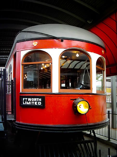
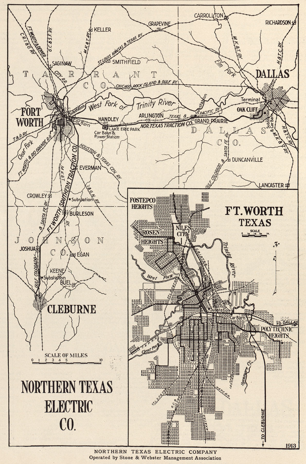
In 1901 the first interurban to be constructed in Texas, the Denison and Sherman Railway, ran ten miles between Denison and Sherman. The second, in 1902, was the Northern Texas Traction Company, which ran thirty-five miles between Dallas and Fort Worth. Operations ceased in 1934.
The Texas Traction Company constructed a sixty-five-mile line from Dallas to Sherman in 1908. The company purchased the Denison and Sherman Railway in 1911. In 1912 the J. F. Strickland interests, which controlled the Texas Traction Company, purchased the twenty-eight-mile line built by the Dallas Southern Traction Company from Dallas to Waxahachie and named it the Southern Traction Company. In 1913 that railway was built on to Waco, and a fifty-six-mile line from Dallas to Corsicana was completed. In 1917 the Texas Traction Company and the Southern Traction Company merged to form the Texas Electric Railway Company, the largest interurban railway in the South, with more than 200 miles of track. The Dallas-Corsicana branch was discontinued in 1941 and the Dallas-Waco and Dallas-Denison branches in 1948.

Texas Electric Railway map:

History:
http://libraries.uta...se01/txrail.htm
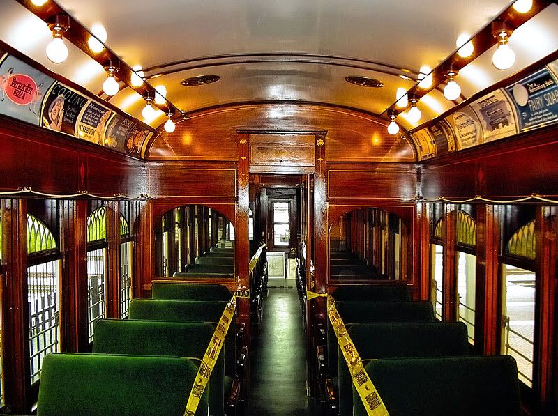
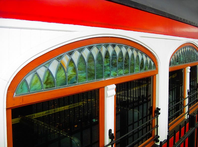
From 1916 until 1948, the Texas Electric Railway provided passenger and freight service to the citizens of North Central Texas. The railway combined the operations of the Texas Traction Company and the Southern Traction Company. With Dallas as its center, the railway operated three lines: one to Sherman and Denison, one to Ennis and Corsicana, and one to Hillsboro and Waco. These routes gave the Texas Electric 226 miles of track, making it the longest interurban west of the Mississippi River. While primarily a passenger line, Texas Electric Railway also offered mail and express service. In 1928, it began to haul freight as well and provided streetcar service in several towns that it served. The Texas Electric Railway was the last independent interurban line in Texas by 1942. While the line operated throughout World War II, ridership declined after the war due to the surge in private automobiles, buses, and trucks. The last run of the Texas Electric was on December 31, 1948.

Texas Interurban Railway Company
http://www.tshaonlin...s/EE/eqe12.html
History:
Smaller systems operated around Texas. The Texas Interurban Railway Company had two lines, a twenty-nine-mile run between Dallas and Terrell from 1923 to 1932 and a thirty-eight-mile run from Dallas to Denton from 1924 to 1932.

Fort Worth Southern Traction Company
http://www.tshaonlin...s/EE/eqe12.html
History:
The Fort Worth Southern Traction Company opened thirty miles of track between Fort Worth and Cleburne in 1912. This company was reorganized in 1914 as the Tarrant County Traction Company, which was subsequently acquired by the Northern Texas Electric Company. The latter became the Northern Texas Traction Company, which closed the line in 1931.

Edited by AndyN, 16 July 2009 - 10:34 AM.
Split from SW2NE Thread


#2 Electricron

Electricron

    Elite Member

  • Members
  • PipPipPipPipPipPip
  • 769 posts

Posted 16 July 2009 - 09:13 PM

I posted more data on Interurbans in this thread, but someone made a new thread of it.

If you checked each Interurban Line, not specifically each company because they tended to buy each other out over time, you'll discover that the longest life of any of the rail lines was around 30 years, about the time the rails or tracks on the ground needed replacing.

The Interurban Railways made enough cash to pay off their own operations and maintenance, but not enough to pay for new capital expenses, like replacing all the tracks when that time came.

Fares were set at the time by the Railroad Administrations, both State and Federal. Isn't it a shame that government agencies wouldn't let them charge fares high enough so they could replace aging tracks and continue to remain in business.

That bad times also occurred during the depression, and it was basically impossible for private businesses to borrow or raise any cash. That's why they all were closed, not any GM scheme to put them all out of business.

Edited by AndyN, 16 July 2009 - 09:58 PM.
Moved off-topic post to correct thread.


#3 FoUTASportscaster

FoUTASportscaster

    Advanced Member

  • Members
  • PipPipPipPipPip
  • 362 posts

Posted 17 July 2009 - 06:00 AM

That's not exactly true. These companies also paid taxes. These were essentially property taxes on equipment and real estate. So, because they owned the ROW, they paid taxes on it. Bus companies didn't, giving a financial incentive to rubber tired transport. Also, some of these taxes paid by the Interurbans went to construction of highways (I know, I have studied their books), in essense making the interurban companies pay for their own eventual demise.

In the case of the Texas Electric, they had a string of accidents in a row. After the third one in a limited time period, they decided they couldn't pay anymore in related expenses, which caused them to shut her down in Dec. of 1948.

#4 Brian Luenser

Brian Luenser

    Skyscraper Member

  • Members
  • PipPipPipPipPipPipPip
  • 3,083 posts
  • Gender:Male
  • Location:Downtown Fort Worth

Posted 17 July 2009 - 06:11 AM

Great maps of the Interurban lines. I used to work for an old CPA whose family came from Cleburne. He talked frequently about taking the train from Cleburne to Fort Worth and to Dallas. His family used to come to Fort Worth to see the Cats play. He can still tell you all the players of the 30's etc...

This old guy is still a practicing CPA (121 and Sylvania) at the little CPA firm where I got my start out of school. When I was working there in the 80's, I was living in Arlington and did not care about all his Fort Worth stories. (Their family moved to Polytechnic Heights when he was a teenager) I drive by his business every day coming home from work and want to stop in and talk Fort Worth with again now that I care. I believe this man is 90 so I don't want to necessarily wait another 20 years to visit with him. He lives in the Meadowbrook area now after buying a "Big Beautiful new home" in the 60's.
Funny, I can look at his little CPA firm out my window here from downtown. I remember when I worked there I would walk out on the front porch and look downtown and see the building (Fort Worth National) that I am now sitting in looking toward it.

What I want to see a picture of, is the Jett building downtown when it had the Interurban line going in and out of it back when it was their headquarters. I don't believe I have ever seen such a thing.
www.fortworthview.com

#5 AndyN

AndyN

    Skyscraper Member

  • Moderators
  • PipPipPipPipPipPipPip
  • 2,280 posts
  • Gender:Male
  • Location:Downtown Fort Worth

Posted 17 July 2009 - 09:55 AM

I would have to agree with Foutasportscaster that the reason for closure of the lines was not aging infrastructure, although it didn't help. I am aware of specific instances on the Texas Electric where the tracks had been upgraded, so it is incorrect to assume that the lines closed operating on the same rails that the were built with.

The chief mechanical officer of MATA has a guard rail off of one of the interurban cars had the head-on crash between Royal and Walnut Hill Lane. The result of this accident was a bunch of lawsuits and a recommendation by the ICC to install a block system. The TERy decided to shut down rather than upgrade. The accident report is available at The ICC Archive under 1948 - Texas Electric.

As for the Northern Texas Traction lines, the parent company, Stone & Webster, lost an anti-trust suit by the federal government which prohibited them from owning both the electric plants and the electric railways. Stone & Webster had already dealt with several years of decreased ridership due to automobile competition and could see that the power generation side of the business would make them more money so they sold off or shut down their transit operations.

For Monee9696, the cars never enterred the Jett building, if I understand your post correctly. The cars passed in front of the building in the middle of Main Street, and I am not even aware of a sidetrack or anything located there. It is my understanding of the building that it was more of a corporate office and ticket location, not a full blown station.
Www.fortwortharchitecture.com

#6 djold1

djold1

    Elite Member

  • Members
  • PipPipPipPipPipPip
  • 689 posts
  • Gender:Male
  • Location:76179

Posted 18 July 2009 - 08:20 PM

QUOTE
As for the Northern Texas Traction lines, the parent company, Stone & Webster, lost an anti-trust suit by the federal government which prohibited them from owning both the electric plants and the electric railways. Stone & Webster had already dealt with several years of decreased ridership due to automobile competition and could see that the power generation side of the business would make them more money so they sold off or shut down their transit operations.


Not quite. At least as far as the Dallas-Fort Worth area was concerned.

While the story about Stone & Webster wanting to stay in the power generation business has floated around this area forever, it just isn't true.

The true facts are that Stone & Webster sold their Handley power plant, their transmission lines and their city electric franchises in June or July of 1930 to Texas Electric Service Co. This was reported in the newspapers at the time and is in their 1930 Company Report of which I have a copy.

Back in 1929 as part of a large expansion plan, TESCO had purchased the Fort Worth Power & Light Company and had integrated it into their fast growing system. Northern Texas Traction Co. supplemented the power they generated at Handley with FWP&L current when needed. TESCO was also picking up smaller west Texas power systems as well during this period.

Under Stone & Webster, the NTT Cleburne Interurban division lasted until 1931 and the Fort Worth - Dallas Interurban lasted until December 1934. The Interruban ROW became the south lane of East Lancaster and old Highway 80. The last Fort Worth streetcars apparently ran in 1938 and were the victim of a brutal franchise battle precipitated by the election of a very radical New Deal era city government that wanted to force 5 cent "Nickel" fares for riders instead of the 7 cent fare, and to get the tracks out of the street for motorists and pedestrians.

The whole story is well documented and pretty interesting. It does not involve GM or the National City Lines as villains. In fact, the story plays out like a black comedy of errors. The city fathers of that period tried to operate the city like a Banana Republic. The arguements used to promote transit buses sound exactly like a lot of the transit controversy today, except that the streetcars were the bad guys and the buses were the "modern" way to go. To top things off, the "bad" streetcar guys (NTT) were awarded the all-bus franchise and operated as the privately owned Fort Worth Transit Co. until the 1970's. The WPA paid for most of the streetcar rail removal by about 1940. The 5 Cent fares never happened.

As most people are aware, TESCO eventually became TXU and ONCOR which are mostly famed and cursed for their out-sourced New Delhi customer support(?) group dedicated to supplying incomprehensible faux English responses to desperate customers without power.

Pete Charlton
The Fort Worth Gazette blog
The Lost Antique Maps of Fort Worth on CDROM
Website: Antique Maps of Texas
Large format reproductions of original antique and vintage Texas & southwestern maps


#7 Lacyt

Lacyt

    Newcomer

  • Members
  • Pip
  • 2 posts

Posted 10 September 2009 - 08:48 PM

Does anybody know exactly where the "Hillsboro-Waco Public Road" is/was? Specifically, where it ran north through Waco? If it still exists, what is it called now? I pulled a 1913 property description at the McLennan County Deed Records today, where several landowners granted TP&L the right of way for the Interurban, and the metes and bounds for the ROW included this Public Road. If you have that Public Road on an old map, specifically the 1913 time frame, I'd really appreciate seeing it or or being pointed to where I can view it.

Thanks!

#8 djold1

djold1

    Elite Member

  • Members
  • PipPipPipPipPipPip
  • 689 posts
  • Gender:Male
  • Location:76179

Posted 11 September 2009 - 08:18 AM

A quck but not totally accurate answer would be to follow the power line towers between the two cities. In various places a county road still exists running more or less alongside them. In 1913 there were no state roads. The Counties maintained the roads which connected at county lines.

These roads did not follow a straight line like an interurban or railroad ROW would do. They jogged back and forth along the section lines and tried to take the easiest grades or the paths that were less expensive to build. They often crossed the rails lines back and forth to get where they were going.

I think I remember many years ago leaving Waco and at the outskirts of town cutting over to the east and finding such a road which I followed for a while.

Also in Waco itself, the towers are also a good general indication on the north side.

Quite possibly remnants of these roads might show up on Goggle Earth or other satellite maps.

Probably if maps exist they would be the official county road maps of the period. I would also be interested in seeing them.

John Myers included excellent TERR system maps of large scale in his great Texas Electric book but they seldom if ever showed any roads, except important crossings.

Pete Charlton
The Fort Worth Gazette blog
The Lost Antique Maps of Fort Worth on CDROM
Website: Antique Maps of Texas
Large format reproductions of original antique and vintage Texas & southwestern maps


#9 M C Toyer

M C Toyer

    Member

  • Members
  • PipPipPip
  • 58 posts

Posted 12 September 2009 - 07:00 AM

QUOTE (Lacyt @ Sep 10 2009, 09:48 PM) <{POST_SNAPBACK}>
If you have that Public Road on an old map, specifically the 1913 time frame, I'd really appreciate seeing it or or being pointed to where I can view it.


Lacyt -

I have a couple of maps, ca 1918 and 1936, that show county roads running from Waco to Hillsboro. The roads are not labeled but all the railroads and interurban are and you can trace the route, The maps also show some structures and landmarks.

Pete's (djold1) decription of the roads is very appropriate. The later federal highway route (US 67/US 81) generally ran parallel to the interurban while the earlier roads meandered in the general direction, crossing the tracks, and taking 90 degree turns at property lines.

The maps are too large to post here - email me at: mctoyer@hotmail.com

M C

addendum: On the current Mapquest.Com website there is a road which branches northwest from Elm Street that is initially labeled Clifton Street but further north is labelel So. Old Dallas Road. That is essentially the same route shown on the ca 1918 and ca 1936 maps. It is also shown on an 1890 map prior the interurban but after some of the railroads which are shown.

I note on Mapquest the original US 77 route, now Business Route, is labeled New Dallas Highway and also Lacy Drive in some sections. Is there a family connection here?

#10 Lacyt

Lacyt

    Newcomer

  • Members
  • Pip
  • 2 posts

Posted 21 May 2010 - 12:37 PM

QUOTE (M C Toyer @ Sep 12 2009, 08:00 AM) <{POST_SNAPBACK}>
QUOTE (Lacyt @ Sep 10 2009, 09:48 PM) <{POST_SNAPBACK}>
If you have that Public Road on an old map, specifically the 1913 time frame, I'd really appreciate seeing it or or being pointed to where I can view it.


Lacyt -

I have a couple of maps, ca 1918 and 1936, that show county roads running from Waco to Hillsboro. The roads are not labeled but all the railroads and interurban are and you can trace the route, The maps also show some structures and landmarks.

Pete's (djold1) decription of the roads is very appropriate. The later federal highway route (US 67/US 81) generally ran parallel to the interurban while the earlier roads meandered in the general direction, crossing the tracks, and taking 90 degree turns at property lines.

The maps are too large to post here - email me at: mctoyer@hotmail.com

M C

addendum: On the current Mapquest.Com website there is a road which branches northwest from Elm Street that is initially labeled Clifton Street but further north is labelel So. Old Dallas Road. That is essentially the same route shown on the ca 1918 and ca 1936 maps. It is also shown on an 1890 map prior the interurban but after some of the railroads which are shown.

I note on Mapquest the original US 77 route, now Business Route, is labeled New Dallas Highway and also Lacy Drive in some sections. Is there a family connection here?


Thank you very much for the information! Old Dallas Road currently runs parallel with the Katy tracks that run past my house which run parallel with the old Interurban line as well. Part of the legal description I have for the R.O.W. granted to TPL for the Interurban states "said point being in a westerly direction 50.0 feet at right angles from the west line of the Hillsboro-Waco Public Road" and it works exactly when you measure from Old Dallas Road out here.

Hwy 77/Lacy Drive/New Dallas Highway/Hwy 81 now merges into I-35. Also dug up some info that seems to indicate 77/Lacy Drive/New Dallas Highway/Hwy 81 was also formerly called "State Highway 2" somewhere in the past.

This answers my question then so thank you all for the info!

And MC, thank you for the offer to provide me those maps. I will email you for copies here directly. Much appreciated! Oh, and no relation. It's derived from the name of a character from a favorite story.

#11 djold1

djold1

    Elite Member

  • Members
  • PipPipPipPipPipPip
  • 689 posts
  • Gender:Male
  • Location:76179

Posted 21 May 2010 - 01:41 PM

QUOTE
Hwy 77/Lacy Drive/New Dallas Highway/Hwy 81 now merges into I-35. Also dug up some info that seems to indicate 77/Lacy Drive/New Dallas Highway/Hwy 81 was also formerly called "State Highway 2" somewhere in the past.


Just a small OT note: Preceding the federal designation as US 81 in 1926, the state highway down from the Oklahoma border through Bowie, Fort worth and San Antonio was designated as State Hwy #2. State Highway #1 from El Paso through Fort Worth and Dallas and on eastward became US 80. US 80/SH #! was also known as the Bankhead National Highway.

Off hand I don't remember what the State Highway number was previous to the designation as US 77, but it definitely wasn't SH #2.

Starting in the early 1900's, the designations for major highways or roads started out as "named" roads (Ex: the Colorado to Gulf Highway which became US 287) then picked up a State Highway number (Ex: SH #2) and then later may have received a Federal designation (Ex: US 81). Until recent years these roads would still be referred to by any of the designations.

I have a 1955 Ashburn Texas road map that shows US Highway 80 as "Bankhead National Highway" interchangeably.

Pete Charlton
The Fort Worth Gazette blog
The Lost Antique Maps of Fort Worth on CDROM
Website: Antique Maps of Texas
Large format reproductions of original antique and vintage Texas & southwestern maps


#12 Electricron

Electricron

    Elite Member

  • Members
  • PipPipPipPipPipPip
  • 769 posts

Posted 21 May 2010 - 09:33 PM

Wiki article on the Bankhead Highway
http://en.wikipedia....ankhead_Highway
The Bankhead Highway was an auto route connecting Washington D.C. to San Diego.
It only followed what was US 80 west of Dallas (now I-20 then I-10), to the east it followed what was US 67 (now I-30).

#13 Dismuke

Dismuke

    Skyscraper Member

  • Members
  • PipPipPipPipPipPipPip
  • 2,098 posts
  • Gender:Male
  • Location:Fort Worth
  • Interests:Late 19th/early 20th century history, popular culture architecture and music. Collecting 78 rpm records from the 1900 - 1930 era.

Posted 21 May 2010 - 10:46 PM

QUOTE (Electricron @ May 21 2010, 10:33 PM) <{POST_SNAPBACK}>
Wiki article on the Bankhead Highway
http://en.wikipedia....ankhead_Highway
The Bankhead Highway was an auto route connecting Washington D.C. to San Diego.
It only followed what was US 80 west of Dallas (now I-20 then I-10), to the east it followed what was US 67 (now I-30).


And Hwy 80 east of where it split with Hwy 67 which is now on the Dallas/Mesquite border, was known as the Dixie Overland Highway which more or less follows modern day Hwy 80 (with various local realignments, of course, taking place over the decades). Later it was often referred to as as The Broadway of America.
Radio Dismuke
1920s & 1930s Pop & Jazz
24-Hour Internet Radio
www.RadioDismuke.com


#14 M C Toyer

M C Toyer

    Member

  • Members
  • PipPipPip
  • 58 posts

Posted 23 May 2010 - 08:27 PM

QUOTE (djold1 @ May 21 2010, 02:41 PM) <{POST_SNAPBACK}>
Just a small OT note: Preceding the federal designation as US 81 in 1926, the state highway down from the Oklahoma border through Bowie, Fort worth and San Antonio was designated as State Hwy #2. State Highway #1 from El Paso through Fort Worth and Dallas and on eastward became US 80. US 80/SH #! was also known as the Bankhead National Highway.

Off hand I don't remember what the State Highway number was previous to the designation as US 77, but it definitely wasn't SH #2.


Pete -

Since US 77 and US 81 shared the same roadway from the north side of Hillsboro to the south side of Waco would not both routes have been State Hwy 2 for that segment?

US 77 north of Hillsboro via Italy, Waxahachie, Dallas, Mc Kinney and Denison was State HWY 6. In the 1930s US 77 designation north of Dallas switched to the Denton - Gainesville route (aka SH 40) and the Dallas to McKinney to Denison route became US 75.

M C

#15 djold1

djold1

    Elite Member

  • Members
  • PipPipPipPipPipPip
  • 689 posts
  • Gender:Male
  • Location:76179

Posted 23 May 2010 - 09:12 PM

QUOTE
Since US 77 and US 81 shared the same roadway from the north side of Hillsboro to the south side of Waco would not both routes have been State Hwy 2 for that segment?


You're right MC. The route to San Antonio and south was SH2 from Hillsboro on. This showed on a number of maps even after WWII. And if I'm not mistaken, US 81 ends at the point in north Fort Worth where it and its co-0road US 287 junction with IH35W.

To get slightly back on topic, the Northern Texas Traction interurban pretty much paralleled SH1/US80 from Fort Worth to Grand Prairie and the Texas Electric interurban ran mostly on the east side of SH6/US77 from Dallas to Hillsboro and then east of SH2/US81 on to Waco.

Pete Charlton
The Fort Worth Gazette blog
The Lost Antique Maps of Fort Worth on CDROM
Website: Antique Maps of Texas
Large format reproductions of original antique and vintage Texas & southwestern maps


#16 M C Toyer

M C Toyer

    Member

  • Members
  • PipPipPip
  • 58 posts

Posted 23 May 2010 - 10:16 PM

QUOTE (Electricron @ May 21 2010, 10:33 PM) <{POST_SNAPBACK}>
Wiki article on the Bankhead Highway
http://en.wikipedia....ankhead_Highway
The Bankhead Highway was an auto route connecting Washington D.C. to San Diego.
It only followed what was US 80 west of Dallas (now I-20 then I-10), to the east it followed what was US 67 (now I-30).


The original Bankhead Highway / US 67 / SH 1 from Greenville to Dallas followed present SH 66 to Garland, then Garland Road to East Grand, Haskell and Commerce Street. There is still a short stretch in Garland named Bankhead Street. Up until about 10-15 years ago parts of the SH 66 roadway around Caddo Mills, Royce City and Fate was the original segmented concrete slabs. It has since been widened and covered in asphalt.

US 80 east from Dallas was also SH 15.

The original US 67 / SH 1 and US 80 / SH 15 split on East Grand at Samuels Blvd, aka East Pike.

The new US 67 was constructed in the early 1950s and departed East Grand at Samuell Blvd / East Pike sharing the US 80 route to the split Dismuke noted below.

I-30 generally follows the new US 67 route except in the towns.


QUOTE (Dismuke @ May 21 2010, 11:46 PM) <{POST_SNAPBACK}>
And Hwy 80 east of where it split with Hwy 67 which is now on the Dallas/Mesquite border, was known as the Dixie Overland Highway which more or less follows modern day Hwy 80 (with various local realignments, of course, taking place over the decades). Later it was often referred to as as The Broadway of America.


US 80 / SH 15 east from Dallas was also known as the Texas - Louisiana Highway.

US 80 across Texas was designated as the World War II Veterans Memorial Highway in 1944 and that additional designation appeared on maps for decades but funding for signage was never appropriated. A 2005 Texas House bill directed TX-DOT to erect appropriate signs at each end of the highway as well as at each county line crossed by the highway however the Department of Transportation is not required to design, construct, or erect a marker unless a grant or donation of private funds is made to the department to cover the costs.


It seems we've drifted from the original subject so the moderators may wish to move these latest posts to a new thread.

M C

#17 Dismuke

Dismuke

    Skyscraper Member

  • Members
  • PipPipPipPipPipPipPip
  • 2,098 posts
  • Gender:Male
  • Location:Fort Worth
  • Interests:Late 19th/early 20th century history, popular culture architecture and music. Collecting 78 rpm records from the 1900 - 1930 era.

Posted 23 May 2010 - 10:23 PM

Here's an Interurban question that someone here might be able to answer: To what degree where the trains actually used for daily commutes to and from work? I tend to guess not a lot based on the fact that the housing stock in that era in towns along the various routes such as Italy, Hillsboro, Mesquite, Forney, Terrell, etc. was comparable, if not even smaller, than other towns without an Interurban nor did they result in any significant population boom that I am aware of as a result of it. The only point along the route that comes to my mind as resulting in a bedroom community is the Urbandale/Parkdale area of East Dallas.

I am just curious if my guess on this is mostly correct. And, if so, why wasn't it used more for commuting? Seems to me that one could have lived "out in the country" outside of a place like Hillsboro while still holding a job in a place like Dallas or Waco, which, unlike today, was then a vibrant city. Maybe Hillsboro is a bit far out in terms of the time it would take for the trains to travel. But places such as Mesquite or Forney are close in enough that it would not have taken long to travel into Dallas. Was it that the fares were perhaps too expensive to make it viable? Or was it just not something that typically occurred to most people to do?
Radio Dismuke
1920s & 1930s Pop & Jazz
24-Hour Internet Radio
www.RadioDismuke.com


#18 Dismuke

Dismuke

    Skyscraper Member

  • Members
  • PipPipPipPipPipPipPip
  • 2,098 posts
  • Gender:Male
  • Location:Fort Worth
  • Interests:Late 19th/early 20th century history, popular culture architecture and music. Collecting 78 rpm records from the 1900 - 1930 era.

Posted 24 May 2010 - 12:32 AM

QUOTE (M C Toyer @ May 23 2010, 11:16 PM) <{POST_SNAPBACK}>
The original US 67 / SH 1 and US 80 / SH 15 split on East Grand at Samuels Blvd, aka East Pike.


Thanks for posting that. I have wondered exactly where it might have been - and that makes perfect sense. For a brief while, I was under the impression that there might have been a traffic circle near where Buckner crosses Samuels and modern I-30 thinking that might have been where the split was. The Circle Grill that once existed nearby - and which I understand has been revived - also made me wonder if perhaps that is where the restaurant took its name from. But, apparently, there never was such a traffic circle.

Now, here is something about Hwy 80 which I WILL ultimately tie in with the Interurbans.

Prior to 1931, the section of old Hwy 80 between Mesquite and Forney was notorious to cross country travelers. People at the time called it "The Forney Gap" because the road through the East Fork Trinity River bottoms was unpaved and almost impassible to drive on in wet weather and thus constituted a "gap" in terms of it being a usable coast to coast road. The bridge across the East Fork Trinity was very long and was a single lane - which meant that only traffic in one direction could be on the road at any given moment and, if cars from both directions happened to go on at the same time, one of them had to back up. When there was wet weather or when the river bottom flooded, traffic was diverted via Heath to Rockwall and the Bankhead Highway.

In 1931, a new alignment of the highway and a new, modern concrete bridge was built to the north along the present route of Hwy 80 and thus made travel to and from Dallas much quicker and easier. This closing of "the Forney Gap" was considered a very big deal at the time and was reported in newspapers all across the state.

The old dirt road through the Trinity River bottoms has been blocked off for years at both ends, though the ruts remain. It began on the Mesquite side where Scyene Road dead ends into Lawson Road and on the Forney side where West Trinity St dead ends into the river bottoms. After the new highway was built, the road and the bridge remained in service for several more decades.

I have very vague memories of my parents driving down that road a couple of times sometime during the 1970s when I was a very small child. The reason that memory has remained is because going across the bridge was VERY scary - it was very narrow and rickety looking and I was convinced that my parents were going to drive the car off the bridge. Not long after that, the barricades that, to this day, block the road off were put up because part of the bridge was apparently washed out in a flood.

Anyhow the memory of that bridge stayed with me and fascinated me throughout my childhood. I never was able to convince my parents to take me on a walk down to the river so that I could see it again. However, years later, after I became an adult, I decided to take that walk and brought a camera with me. All that is left of the bridge is the span that crosses the river itself. However, from what I have been told by my parents and others, rather lengthy elevated approaches across the river bottom led up to that span. My parents also tell me that in the middle of those approaches, the bridge actually made a bend which was somewhat unusual and made it even more scary to drive across.

Here is where the Interurbans come in - not far to the south of the old bridge are the concrete pillars that once supported the Interurban bridge across the river.

So here are some photos:

The first photo is from the aerial shot on Bing Maps. At the very top you can see the present day T&P/Union Pacific tracks. In the middle you can see the surviving span of the old highway bridge. Towards the bottom, you can see the concrete Interurban bridge supports.


Next are two of the photos I took of the old iron highway bridge when I took that walk.


I have always been curious to know when the bridge was built. I am not all that knowledgeable about old bridges. Perhaps someone here who is might be able to give an approximate date range based on the span. It is entirely possible that the route predated the highway as the very early highways were merely routes that made use of preexisting roads.

Finally, here are the supports for the Interurban Bridge


Radio Dismuke
1920s & 1930s Pop & Jazz
24-Hour Internet Radio
www.RadioDismuke.com


#19 Electricron

Electricron

    Elite Member

  • Members
  • PipPipPipPipPipPip
  • 769 posts

Posted 24 May 2010 - 06:33 AM

QUOTE (Dismuke @ May 23 2010, 11:23 PM) <{POST_SNAPBACK}>
Here's an Interurban question that someone here might be able to answer: To what degree where the trains actually used for daily commutes to and from work? Maybe Hillsboro is a bit far out in terms of the time it would take for the trains to travel. But places such as Mesquite or Forney are close in enough that it would not have taken long to travel into Dallas. Was it that the fares were perhaps too expensive to make it viable? Or was it just not something that typically occurred to most people to do?


People didn't commute back then from the country, that what it was called back then, into the cities for jobs. Country people went into the cities, even into the small towns, for business, shopping, and entertainment. An interurban averaging 35 mph between Forney and Dallas could get you into Dallas in about an hour. Your own Model T pickup truck, on dirty roads and highways, maybe averaged 25 to 30 mph. There were no paved highways nor freeways where you could drive 50 mph or faster on. Taking the interuban was faster.
Once you got to downtown Dallas, there was no place to park. There were no parking garages and there were no empty lots used for parking either. You didn't need your own car or truck, there were streetcars you could hop upon to get around. Taking the interurban was easier too.
It wasn't until FDR's administration before highways were paved for the new faster Model A cars. Paving highways were the "Recovery" make work projects back then. Money was spent the same year it was allocated back then, because there was no environmental impact process adding years to any construction project.
As the highways were paved and as highways speeds increased, established interurbans died a slow death.


#20 M C Toyer

M C Toyer

    Member

  • Members
  • PipPipPip
  • 58 posts

Posted 24 May 2010 - 09:31 AM

QUOTE (Dismuke @ May 24 2010, 01:32 AM) <{POST_SNAPBACK}>
QUOTE (M C Toyer @ May 23 2010, 11:16 PM) <{POST_SNAPBACK}>
The original US 67 / SH 1 and US 80 / SH 15 split on East Grand at Samuels Blvd, aka East Pike.


Thanks for posting that. I have wondered exactly where it might have been - and that makes perfect sense. For a brief while, I was under the impression that there might have been a traffic circle near where Buckner crosses Samuels and modern I-30 thinking that might have been where the split was. The Circle Grill that once existed nearby - and which I understand has been revived - also made me wonder if perhaps that is where the restaurant took its name from. But, apparently, there never was such a traffic circle.


First, thanks for the details and excellent photos of the historic East Fork Crossings. You had mentioned them before but I'd never had the time for an on-site visit.

Re the US 67 and US 80 split:

There was indeed a traffic circle at Buckner Blvd and the "new" US 67 constructed about 1950. It lies directly under the present Buckner / I-30 interchange.

When the new US 67 was constructed it branched north off Samuell Blvd at about Jim Miller. US 80 continued east from there.

In the present configuration US 67 and US 80 split just east of the Buckner / I-30 interchange. Present US 80 rejoins the pre-Interstate US 80 near Town East Blvd.

Re the iron truss bridge on old US 80 on the East Fork of the Trinity, that desgin was fairly common from the mid 1880s and many built in that era are still in use though on major roads have all been replaced.

I have more specific details on the bridge and earlier routes and crossings of the East Fork that are probably best suited for another thread if not another forum.

M C

#21 Dismuke

Dismuke

    Skyscraper Member

  • Members
  • PipPipPipPipPipPipPip
  • 2,098 posts
  • Gender:Male
  • Location:Fort Worth
  • Interests:Late 19th/early 20th century history, popular culture architecture and music. Collecting 78 rpm records from the 1900 - 1930 era.

Posted 24 May 2010 - 10:31 AM

QUOTE (M C Toyer @ May 24 2010, 10:31 AM) <{POST_SNAPBACK}>
There was indeed a traffic circle at Buckner Blvd and the "new" US 67 constructed about 1950. It lies directly under the present Buckner / I-30 interchange.


Wow. Fascinating. That traffic circle must not have lasted very long, though. I remember the old Buckner Blvd bridge over what was then I-30/I-20 before it was ripped out for the current one and it appeared to have been built sometime in the '50 or early '60s. Do you know when it was destroyed? Presumably it was when the road was upgraded to Interstate.


QUOTE
I have more specific details on the bridge and earlier routes and crossings of the East Fork that are probably best suited for another thread if not another forum.


Oh, please, pretty please, share that info and those details. That is a subject I have wondered about for a very long time and tried to research online but have not been very successful at.

Radio Dismuke
1920s & 1930s Pop & Jazz
24-Hour Internet Radio
www.RadioDismuke.com


#22 M C Toyer

M C Toyer

    Member

  • Members
  • PipPipPip
  • 58 posts

Posted 24 May 2010 - 11:53 AM

QUOTE (Dismuke @ May 24 2010, 11:31 AM) <{POST_SNAPBACK}>
Wow. Fascinating. That traffic circle must not have lasted very long, though. I remember the old Buckner Blvd bridge over what was then I-30/I-20 before it was ripped out for the current one and it appeared to have been built sometime in the '50 or early '60s. Do you know when it was destroyed? Presumably it was when the road was upgraded to Interstate.


The Buckner/Loop 12 and US 67/80 Traffic Circle was somewhat unusual as the orginal design and construction included two overpasses within the circle carrying the north and south bound lanes of Buckner/Loop 12 over the US 67/80 expressway built concurrenly. The central overpass was built in the mid 1970s with the two outer bridges becoming service roads (I believe those bridges were rebuilt or replaced but are in essentially the same location.)


QUOTE
pretty please[/i], share that info and those details. That is a subject I have wondered about for a very long time and tried to research online but have not been very successful at.


I'm having a problem with my photo host and image sizing and was unable to post a legible 1923 Rand McNally map in an earlier post. In the meanwhile contact me direct at M C Toyer and I can e-mail some items.

The earliest account of the East Fork Crossing of the Trinity in that vicinity is from an 1843 diary and is quite specific on the difficulties encountered with the steep banks and adjacent swampy bottomland. (To bring this subject back to a Fort Worth focus the author of the diary was accompanying Sam Houston to treat with Indian tribes at Bird's Fort which led to the establishment of the Trading Houses at Marrow Bone Springs (later known as Johnson Station, a part of present Arlington) and on the Clear Fork of the Trinity in present Fort Worth. Six years later Major Ripley Arnold, accompanied by Middleton Tate Johnson and others, founded Camp Worth)

In 1845 in that same general area the Central National Highway was surveyed but not built.

Before either of those events Colonel William G Cooke's 1840/41 Military Road Expedition was unable to penetrate the thick undergrowth and thus prevented from reaching his intended terminus on Red River at Travis Wright's Landing (between present Paris and Clarksville) and he instead ended up at Fort Inglish (Bonham) and the road terminted at Coffee's Trading House which later became the town of Preston.

In 1851 Goodman's Turnpike Company was chartered by the State of Texas to have a good convenient, safe and substantial bridge across the East Fork of the Trinity River, near the crossing of the old National Road, and within two years they shall construct good, convenient, safe and substantial bridges across all the sloughs which run through said East Fork bottom on the route leading to said river bridge and shall throw up and causeway a turnpike across said bottom, and ditch same well upon each side, so as to make a good, convenient and safe road. (Gammel's Laws of Texas, Vol III)

M C

#23 Brian Luenser

Brian Luenser

    Skyscraper Member

  • Members
  • PipPipPipPipPipPipPip
  • 3,083 posts
  • Gender:Male
  • Location:Downtown Fort Worth

Posted 22 November 2011 - 11:50 AM

Old trolley heading to Burleson. Was surprised that they went as fast as 70 mph back then. (probably 30 safely) My old boss took this trolley from Cleburn to Fort Worth and Dallas as a kid. (Fam would go to Fort Worth for Cats baseball all summer.) This is the 90 some year old CPA that is still at his desk working were I started in Public Accounting in 1984.

Story in yesterday's Star Telegram


http://www.star-tele...e-car-will.html
www.fortworthview.com

#24 bburton

bburton

    Senior Member

  • Members
  • PipPipPipPip
  • 311 posts
  • Gender:Male
  • Location:Fort Worth

Posted 22 November 2011 - 06:55 PM

As many of you know, one of the restored interurban "coaches" is on permanent display at the Intermodal Transportation Center in Fort Worth. :)

Posted Image

Posted Image

Posted Image

Bruce Burton


#25 djold1

djold1

    Elite Member

  • Members
  • PipPipPipPipPipPip
  • 689 posts
  • Gender:Male
  • Location:76179

Posted 22 November 2011 - 08:47 PM

Bob.. These are absolutely stunning pictures! Wow!

For those of you on Facebook... There is more discussion over on The Northern Texas Traction History Group that you might enjoy participating in...

Pete Charlton
The Fort Worth Gazette blog
The Lost Antique Maps of Fort Worth on CDROM
Website: Antique Maps of Texas
Large format reproductions of original antique and vintage Texas & southwestern maps


#26 renamerusk

renamerusk

    Skyscraper Member

  • Banned
  • PipPipPipPipPipPipPip
  • 7,662 posts
  • Gender:Male
  • Location:Fort Worth South

Posted 22 November 2011 - 10:17 PM

Is this a historical perspective or a perspective that suggests it can address some of Fort Worth's present transportation needs? I would certainly be in favor of a discussion about the North Texas Interurban (streetcar) in the latter context.

Keep Fort Worth folksy

#27 djold1

djold1

    Elite Member

  • Members
  • PipPipPipPipPipPip
  • 689 posts
  • Gender:Male
  • Location:76179

Posted 23 November 2011 - 04:13 PM

"Is this a historical perspective or a perspective that suggests it can address some of Fort Worth's present transportation needs? I would certainly be in favor of a discussion about the North Texas Interurban (streetcar) in the latter context."

<br style="color: rgb(28, 40, 55); font-size: 14px; line-height: 20px; background-color: rgb(250, 251, 252); ">

When I started up the NTT History Group, I really had no intention of anything more than just setting the history of the system into perspective and correcting the lore and misunderstandings that have grown up over the years due to the lack of a place to put down the facts. The group has been welcomed nicely and we're getting some good posts and good membership for a niche subject. The initial posts have been a little scattered as everyone is trying out topics and images to see where the immediate interest lies.

In my view the NTTHG is not a "streetcar" group. And I don't anticipate a lot of advocacy entering the picture.

The Northern Texas Traction Co. was a for-profit transportation company. One of a number owned by the Stone and Webster management group in the 1900-1950 period. S&W also owned electric power plants which sometimes worked in tandem with the transit systems until the early 1930's when anti-trust forced divestment. The record shows that S&W was a well financed management company that ran good businesses in a relatively enlightened manner that produced good profits for its stockholders. The NTT was generally considered a good place to work in the Fort Worth Dallas area in those times.

With a profit motive in mind, the NTT did what was necessary to serve their riders and did not indulge themselves in the grotesque and unprofessional conduct of "liking" one mode of public transit over another. At least in public. Initially, they consolidated the many "trolley" lines in Fort Worth by 1910 and then began building a world class set of city streetcar lines that served the most populous sections of the city. The NTT Interurban which opened in 1902 was the only feasible way to go between cities, unless you wanted to take the steam trains which did not run often.

As the roads improved in Fort Worth and more streets were paved, buses were added from 1920 on to give better service to problem areas that could not stand the expense of rail lines. By 1930 almost a quarter of the city lines had buses running. They used what worked. And made money. Like a publicly owned business was expected to. When portions of the NTT stopped making money, they were shut down before the losses became astronomical.

The "T" today, although owned by the city and incapable of producing a profit, still tries to use the same idea. Use what works in a given situation. Buses to cover a lot of territory at a minimum operating cost and incidentally using CNG which produces a environmental profile that is very close to electric propulsion. The TRE uses less desirable diesel engines but moves long-haul similar to the the old Interurban. And I think it's very possible that the "T" and its supporters would embrace electric streetcars if anyone could ever make a rational case for useful ridership that was not based on "boutique" operation over politically gerrymandered routes.

Recently the "T" has introduced large articulated buses on its heavy routes that are visually indistinguishable from "modern" streetcars. It has also proposed eventual diesel rail operation in the median of East Lancaster which is innovative but makes you wonder why "diesel" instead of CNG which is locally produced and already used by almost the entire transit system. Anomalies like this bother me.


Again, I don't see the NTTHG on Facebook as getting into advocacy or even into deep discussions of the transit future of Fort Worth. But I would suggest that there is a lot to be learned in the history of what was a very good transit company that established many of the routes that are still served by the "T" today. And who knows.. if someone opens a thread that relates everything, we might end up in unexplored territory.

The group is civil, free and open. You might enjoy it...


Pete Charlton
The Fort Worth Gazette blog
The Lost Antique Maps of Fort Worth on CDROM
Website: Antique Maps of Texas
Large format reproductions of original antique and vintage Texas & southwestern maps


#28 bburton

bburton

    Senior Member

  • Members
  • PipPipPipPip
  • 311 posts
  • Gender:Male
  • Location:Fort Worth

Posted 25 November 2011 - 11:00 AM

These are absolutely stunning pictures!


Thank you very much. :)

Bruce

Bruce Burton


#29 Electricron

Electricron

    Elite Member

  • Members
  • PipPipPipPipPipPip
  • 769 posts

Posted 08 January 2012 - 11:23 AM

Recently the "T" has introduced large articulated buses on its heavy routes that are visually indistinguishable from "modern" streetcars. It has also proposed eventual diesel rail operation in the median of East Lancaster which is innovative but makes you wonder why "diesel" instead of CNG which is locally produced and already used by almost the entire transit system. Anomalies like this bother me.

According to the Star-Telegram, the diesel rail proposal within the median of Lancaster would be using Stadler GTWs - similar to what DCTA will introduce later this year for its A-Train. It's just one of many alternatives for the East Lancaster corridor environmental study, including the existing bus service at the low end, a rapid bus service with dedicated lanes within the median as middle choice, and this diesel service within the median at the high end.
Not sure why a modern streetcar or light rail line will not be considered as other alternatives - I think they should. If you're planning on using Federal and State funds, alternatives need to be included for every environmental study. I would think electric power propulsion should be included in every transportation study, but I guess the number of alternatives needed to be included in every study isn't defined by law. I believe the diesel alternative at the high end was chosen for the study because it is the worse environmentally, and therefore would make either bus alternative look better. Which means it's there so it wouldn't be picked, i.e. FWTA has already decided to use buses unofficially. The real purpose of the study is to help convince the FTA for Federal funds to install dedicated bus lanes within the median.
As for diesel power vs natural gas power for GTWs, Stadler has never built a natural gas powered GTW. But they have built diesel and electric powered GTWs. Considering what I stated earlier, I'm not that surprised FWTA overlooked electric powered GTWs for this study.
I would like to note that Stadler GTWs are street legal in Texas, CapMetro's Red Line trains uses GTWs for several blocks in downtown Austin, and have met all TXDOT requirements to be registered as highway vehicles. So, they can run on streets and highways in Texas, and are a valid choice as an alternative for the study.
Their 300 feet turning radius of GTWs will make them difficult to turn perpendicularly, but Lancaster Road turns into Division in Arlington, eventually to Main Street in Grand Prairie and Davis Street or Fort Worth Avenue in Dallas, is a fairly straight shot all the way from downtown Fort Worth to downtown Dallas.
Considering the UP's refusal to even consider adding commuter rail on its T&P mainline, could this be the initial consideration for using this as an alternate commuter rail corridor to get Arlington and Grand Prairie to join the transit agencies? If it is, I would prefer a modern light rail line instead. Isn't light rail the modern version of an interurban train?

#30 AndyN

AndyN

    Skyscraper Member

  • Moderators
  • PipPipPipPipPipPipPip
  • 2,280 posts
  • Gender:Male
  • Location:Downtown Fort Worth

Posted 25 February 2013 - 01:54 PM

Members of North Texas Historic Transportation, Inc. are working with the T to open the 1913 Interurban car today. One of our members has even plumbed the air whistle to a compressor so we can blow that horn. Here is the T's press release (slightly edited):
 
 
JOIN US IN CELEBRATING 100th ANNIVERSARY OF HISTORIC INTERURBAN TODAY!!!

Monday, February 25 marks the 100th anniversary of the original Northern Texas Traction Interurban (Car 25) that ran the rails between Fort Worth and Dallas between 1913 and 1934. Car 25 was acquired and restored by the Fort Worth Transportation Authority (The T) in 1995 and has been on permanent display at the Fort Worth In...termodal Transportation Center (ITC), located at 1001 Jones Street in Downtown Fort Worth, since 2001.

In honor of the milestone, The T is providing the public with guided tours of its interior between noon - 4 p.m. TODAY, with additional tours taking place in the upcoming weeks. Additional Car 25 tour dates and times will be posted here on our Facebook page soon!

Car 25 is usually locked and the inside viewable only through the windows, so don’t miss your chance to tour the inside of this historical piece of Fort Worth!!!

Www.fortwortharchitecture.com

#31 Joshw

Joshw

    Senior Member

  • Members
  • PipPipPipPip
  • 213 posts
  • Location:North Fort Worth

Posted 25 February 2013 - 04:39 PM

Man, I wish I had seen this earlier. Hopefully I can swing by over lunch on another day that it's open.


#32 Austin55

Austin55

    Skyscraper Member

  • Members
  • PipPipPipPipPipPipPip
  • 9,693 posts
  • Gender:Male
  • Location:Near Southside

Posted 02 April 2016 - 09:43 PM

Does anyone know if there is a map of all the old interburban lines over modern Fort Worth? If not, I'd like to put one together.

#33 Stadtplan

Stadtplan

    Skyscraper Member

  • Members
  • PipPipPipPipPipPipPip
  • 5,949 posts
  • Gender:Male
  • Location:Fort Worth, TX

Posted 15 December 2020 - 12:46 PM

QUOTE
Starting in the early 1900's, the designations for major highways or roads started out as "named" roads (Ex: the Colorado to Gulf Highway which became US 287) then picked up a State Highway number (Ex: SH #2) and then later may have received a Federal designation (Ex: US 81). Until recent years these roads would still be referred to by any of the designations.

I have a 1955 Ashburn Texas road map that shows US Highway 80 as "Bankhead National Highway" interchangeably.


I stumbled upon this photo reading through some local projects looking north from the courthouse with Paddock Park in the foreground:

kI3c5DX.png


Here's a Street View shot for comparison:

aJQ3Ur6.png


#34 AndyN

AndyN

    Skyscraper Member

  • Moderators
  • PipPipPipPipPipPipPip
  • 2,280 posts
  • Gender:Male
  • Location:Downtown Fort Worth

Posted 20 January 2024 - 05:41 PM

Anyone looking for a Northern Texas Traction Crimson Limited Interurban car? No. 417 is available for auction https://www.aumannau...n-70397/details


The car was part of a lake cottage at Eagle Mountain Lake with No. 25 and No. 411 after service ended. No. 25 was restored for static display at the intermodal station and 411 ended up on display in Burleson. 417 was acquired by the now-defunct Edwards Car company and was partially restored and converted to dining car service. The car is in very good condition and even has its crimson and milk glass stained glass windows in storage. The car was being converted in the Kershaw building but was abandoned there after they folded. Mr. Kershaw has since passed and the entire collection is up for auction. Mr. Kershaw had an incredible collection and there are several other railcars and rare automobiles on the block.


You might be able to get the car for $1 or $10, but shipping from the building in Montgomery, Alabama could cost you in excess of $10k. Good luck.


ntt407-2023.jpg


Www.fortwortharchitecture.com

#35 AndyN

AndyN

    Skyscraper Member

  • Moderators
  • PipPipPipPipPipPipPip
  • 2,280 posts
  • Gender:Male
  • Location:Downtown Fort Worth

Posted 15 March 2024 - 01:00 PM

The auction has concluded and I am relieved to report that someone did buy the NTT Crimson Limited Interurban trailer, No. 417. The car received no bids for most of the duration of the auction but it ended up selling for $8,000. The car is largely wood with steel reinforcement, so that bid amount tells me the buyer is looking for something more than scrap value (unless they are planning to recycle the wood). Unfortunately, the winning buyer is unknown except that they are based in North Carolina. I look forward to learning more about the buyer and their identity.


Www.fortwortharchitecture.com


1 user(s) are reading this topic

0 members, 1 guests, 0 anonymous users