I'm trying to remember this place. If you came north on I-35 from south of town and exited onto Airport Freeway/121, it would be on the right. I can't remember if it was on the east or west side of the river, but it was this old big building, maybe two stories. They occasionally had events or parties or other large gatherings there. I can barely remember it at all, but a friend of mine brought it up and then I remembered seeing it back in the 80s. I don't remember when it disappeared or what it was called, or any history of the place. Do any of you know what place I'm talking about?
Thanks!
John


What was that big hall, east side of I35 and Airport Freeway?
Started by John Cirillo, Jan 31 2008 12:18 AM
17 replies to this topic
#2

John T Roberts
-

- Admin
-

- 16,414 posts
Administrator
- Gender:Male
- Location:South Fort Worth
- Interests:Architecture, Photography, Bicycling, Historic Preservation
Posted 31 January 2008 - 05:45 AM
I think it was an old Masonic Lodge, or something like that, serving the old neighborhood around the river. I think it was demolished in either the late 1980's or early 1990's.
#3
Roger_H
-

- Members
-
- 119 posts
Member
- Location:SW/FW
Posted 07 February 2008 - 08:37 PM
John is correct, it was an old lodge. I believe it was actually an African-American Lodge that had been there for a long time. As I recall, the building was of some historic interest both because of its age and its connection to the African-American community. However, it had suffered from years of neglect and the lodge didn't have any money for restoration.
#4
John Cirillo
-
- Members
-
- 32 posts
Junior Member
Posted 08 February 2008 - 07:33 PM
QUOTE (Roger_H @ Feb 7 2008, 09:37 PM) <{POST_SNAPBACK}>
John is correct, it was an old lodge. I believe it was actually an African-American Lodge that had been there for a long time. As I recall, the building was of some historic interest both because of its age and its connection to the African-American community. However, it had suffered from years of neglect and the lodge didn't have any money for restoration.
Is this building in any of those old Tarrant County Historic Resources Survey books? I only have the Central Business District edition. It goes out to about the 1000 block of downtown. There is a Knights of Pythias at 900 E. Second which was African-American, and the Afro-American Odd Fellows was at 415 E. 6th. It's not those, obviously. I sure wish I had bought the rest of the set when those books came out. Does anyone have the others? Maybe this building is in one of them.
Thanks,
John Cirillo
#5
John T Roberts
-
- Admin
-
- 16,414 posts
Administrator
- Gender:Male
- Location:South Fort Worth
- Interests:Architecture, Photography, Bicycling, Historic Preservation
Posted 08 February 2008 - 10:15 PM
I have the others and I couldn't find the listing. I'm not saying that it wasn't there, it was just difficult to track it down since I didn't know which volume it could be found and I wasn't sure on the name. I will continue to search this weekend.
On a related note, Historic Fort Worth owns those resource books and I chair the commitee that is responsible for them. I'm proud to announce that we are very close to releasing an update to the South Side Survey.
On a related note, Historic Fort Worth owns those resource books and I chair the commitee that is responsible for them. I'm proud to announce that we are very close to releasing an update to the South Side Survey.
#6
John Cirillo
-
- Members
-
- 32 posts
Junior Member
Posted 08 February 2008 - 11:02 PM
QUOTE (John T Roberts @ Feb 8 2008, 11:15 PM) <{POST_SNAPBACK}>
I have the others and I couldn't find the listing. I'm not saying that it wasn't there, it was just difficult to track it down since I didn't know which volume it could be found and I wasn't sure on the name. I will continue to search this weekend.
On a related note, Historic Fort Worth owns those resource books and I chair the commitee that is responsible for them. I'm proud to announce that we are very close to releasing an update to the South Side Survey.
On a related note, Historic Fort Worth owns those resource books and I chair the commitee that is responsible for them. I'm proud to announce that we are very close to releasing an update to the South Side Survey.
I guess it would help if I knew the name of it and a better idea where it was. I almost think it was on the east of the river levee just before Sylvania. There's a little strip of 1st street by there. A friend of mine said she has a picture of it. WHen she comes forth with it, I can show it around and see if it gives a better idea.
I guess that the rest of those historic books are now out of print. I missed my chance to get them, apparently.
Are direct sales planned when the South Side Survey is released? I am not in Fort Worth, so online ordering would be convenient.
I was thinking if I could find any broad coverage aerials of downtown before probably 1985, that building would still be there and it would be easier to pinpoint. I haven't found any aerials on this site that happen to cover that area. I wouldn't know where else to look.
I do seem to remember that the building was actually available for renting out for large parties or was it a Halloween spook house? But I definitely remember gatherings that occurred there in the early 80s, and if I recall they were things you could buy tickets for and were not African-American centered. How dim those memories are though.
I'm trying to remember who else remembered those things.
Well, I feel pretty close to finding the answer. There's no hurry.
Thanks,
John Cirillo
#7
M C Toyer
-

- Members
-
- 58 posts
Member
Posted 09 February 2008 - 09:43 AM
You can view the building's footprint on the Sanborn Insurance Maps online.
It was located north of 1st Street, east of Booker Washington, west of the River.
1926 Vol 2 Sheet 264: Masonic Mosque, AF & AM
1951 Vol 2 Sheet 264: McDonald College of Industrial Arts & Masonic Mosque, AF & AM (Colored)
M C
It was located north of 1st Street, east of Booker Washington, west of the River.
1926 Vol 2 Sheet 264: Masonic Mosque, AF & AM
1951 Vol 2 Sheet 264: McDonald College of Industrial Arts & Masonic Mosque, AF & AM (Colored)
M C
#8
John Cirillo
-
- Members
-
- 32 posts
Junior Member
Posted 09 February 2008 - 11:03 AM
QUOTE (M C Toyer @ Feb 9 2008, 10:43 AM) <{POST_SNAPBACK}>
You can view the building's footprint on the Sanborn Insurance Maps online.
It was located north of 1st Street, east of Booker Washington, west of the River.
1926 Vol 2 Sheet 264: Masonic Mosque, AF & AM
1951 Vol 2 Sheet 264: McDonald College of Industrial Arts & Masonic Mosque, AF & AM (Colored)
M C
It was located north of 1st Street, east of Booker Washington, west of the River.
1926 Vol 2 Sheet 264: Masonic Mosque, AF & AM
1951 Vol 2 Sheet 264: McDonald College of Industrial Arts & Masonic Mosque, AF & AM (Colored)
M C
That is useful information. Thanks.
How and where can I access the Sanborn Maps online? Do I have to be a member of something or pay to see them?
This would be very useful.
Thanks,
John
#9
M C Toyer
-
- Members
-
- 58 posts
Member
Posted 09 February 2008 - 11:19 AM
QUOTE (John Cirillo @ Feb 9 2008, 11:03 AM) <{POST_SNAPBACK}>
How and where can I access the Sanborn Maps online? Do I have to be a member of something or pay to see them?
The Sanborn Maps for the entire state of Texas are available through the Texshare Database website here:
http://www.tsl.state...us/texshare/pl/
There is no charge but you will need a Log-In and Password that can be obtained through any participating library where you have a card (list on website).
M C
#10
John T Roberts
-
- Admin
-
- 16,414 posts
Administrator
- Gender:Male
- Location:South Fort Worth
- Interests:Architecture, Photography, Bicycling, Historic Preservation
Posted 09 February 2008 - 07:40 PM
Even though you have posted the location, I remember it was very close to the freeway service roads.
#11
John Cirillo
-
- Members
-
- 32 posts
Junior Member
Posted 09 February 2008 - 10:13 PM
QUOTE (John T Roberts @ Feb 9 2008, 08:40 PM) <{POST_SNAPBACK}>
Even though you have posted the location, I remember it was very close to the freeway service roads.
Now that I had a better clue where it is, I looked on the Google aerial maps and there you can still see the foundation of the building just at the end of 1st street. And it looks like the way you had to go to get there was the service road along the east side of I-35, probably from 4th street. That is the same service road that goes under the freeway to get back to Belknap.
Yes, I'd say it was very close to the service road!
Well, this is great. At least now I have it located. Thanks, everyone, for helping.
John
#12
John Cirillo
-
- Members
-
- 32 posts
Junior Member
Posted 09 February 2008 - 10:18 PM
QUOTE (M C Toyer @ Feb 9 2008, 12:19 PM) <{POST_SNAPBACK}>
QUOTE (John Cirillo @ Feb 9 2008, 11:03 AM) <{POST_SNAPBACK}>
How and where can I access the Sanborn Maps online? Do I have to be a member of something or pay to see them?
The Sanborn Maps for the entire state of Texas are available through the Texshare Database website here:
http://www.tsl.state...us/texshare/pl/
There is no charge but you will need a Log-In and Password that can be obtained through any participating library where you have a card (list on website).
M C
Guess I'm out of luck then. I'm in Indiana. My Fort Worth library card probably expired. If I could even find it.
Thanks though.
John
#13
John T Roberts
-
- Admin
-
- 16,414 posts
Administrator
- Gender:Male
- Location:South Fort Worth
- Interests:Architecture, Photography, Bicycling, Historic Preservation
Posted 09 February 2008 - 10:28 PM
John, the foundation that you see on the far end of East 1st Street is not from this building. The old lodge was cross shaped in plan, and this foundation is linear. I did look at the Sanborn Maps, and Booker Washington was 2 blocks east of Maple Street. There are remnants of Maple in existence, so the lodge was closer to the curve of the service roads between I-35W and 121.
#14
John Cirillo
-
- Members
-
- 32 posts
Junior Member
Posted 10 February 2008 - 08:37 PM
QUOTE (John T Roberts @ Feb 9 2008, 11:28 PM) <{POST_SNAPBACK}>
John, the foundation that you see on the far end of East 1st Street is not from this building. The old lodge was cross shaped in plan, and this foundation is linear. I did look at the Sanborn Maps, and Booker Washington was 2 blocks east of Maple Street. There are remnants of Maple in existence, so the lodge was closer to the curve of the service roads between I-35W and 121.
That's what my friend who remembers it says too... I don't know what that linear foundation is. But where is the foundation for the Masonic Mosque then? I looked closely on the best online maps I could find, and there's no evidence of another foundation between that one I spotted and where B. Washington would have been. Strange. I would think there would be a trace. It's only been 30 years hasn't it, at most. (Now I wonder what that thing was that still has a foundation there.)
Oh well. At least we know about where it was.
John
#15
Phil Phillips
-

- Members
-
- 240 posts
Senior Member
- Gender:Male
- Location:DWG, TX
Posted 13 February 2008 - 03:10 PM
The linear foundation was a simple metal building with space for maybe two or three small businesses. More warehouse than office. Strong winds with a storm blew most of it down about 10 to 15 years ago and the owners demolished the rest. I remember reading a Star-T story about the cross-shaped structure around the time it was torn down. It was known as a venue for famous African-American musicians in the 40s and 50s, maybe into the 60s.
#16
M C Toyer
-
- Members
-
- 58 posts
Member
Posted 13 February 2008 - 06:32 PM
QUOTE (John Cirillo @ Feb 10 2008, 08:37 PM) <{POST_SNAPBACK}>
But where is the foundation for the Masonic Mosque then? I looked closely on the best online maps I could find, and there's no evidence of another foundation between that one I spotted and where B. Washington would have been. Strange. I would think there would be a trace. It's only been 30 years hasn't it, at most. (Now I wonder what that thing was that still has a foundation there.)
John
John
I drove by the site today. There is little evidence that any structure was ever there except for the curbs on East 1st St where Booker Washington intersected. There are a couple of chunks of concrete that might have been part of the foundation, but that entire area shows some evidence of fill and dumping so could have come from anywhere.
By chance I ran into the man who once owned the property and competed the demolition of the Mosque in the mid to late 1980's. He said there was a crawlspace under the building . The entire site was scraped and leveled.
This link show the Mosque, the dwellings along Booker Washington, and two tourist courts along Belknap all partially submerged:
1949 Flood / Belknap Bridge
This ca 1963 photo from TexasFreeway.Com shows the Mosque in the upper left just beyong the Belknap / I-35 interchange. The aerial view is facing south from the I-35 / 28th Street interchange:

Has anyone found any better images?
M C
#17
Roger_H
-
- Members
-
- 119 posts
Member
- Location:SW/FW
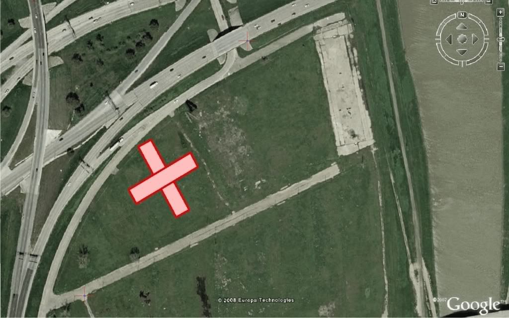
Posted 17 February 2008 - 09:36 PM
Here's where the hall sat:
#18
John Cirillo
-
- Members
-
- 32 posts
Junior Member
Posted 20 February 2008 - 01:32 PM
I sent an email to the Texas Department of Transportation and got them hunting around in their archive.
Today here is the image they sent me, taken in 1966.

This is a really good overhead shot and you can see remnants of the little neighborhood that was west and southwest of the Mosque.
John
Link to Mosque photo
Today here is the image they sent me, taken in 1966.
This is a really good overhead shot and you can see remnants of the little neighborhood that was west and southwest of the Mosque.
John
Link to Mosque photo


0 user(s) are reading this topic
0 members, 0 guests, 0 anonymous users

