
Welcome to the FW Forum, Big Tex. As has been discussed at length in this long thread, the exact location of the pioneer era Cold Springs remains a matter of conjecture. There were various springs throughout Tarrant County and it appears the name cold springs was generic and applied not to one but several sources of ground water. Moreover, there is evidence of a much silted up spring on the north end of Traders Oak park that is also heavily overgrown and, according to an old (1920's?) newspaper article in the Tarrant County Historical Commission archives, it was called Terry Springs because early landowner Nathaniel Terry (former Lt. Governor of Alabama and staunch defender of the Southern cause in the Civil War) had a plantation home somewhere near where Samuels Avenue begins its decline from the bluff going north towards the Stockyards. The home, which was said to have been built out of native bluff limestone by Terry's slaves, is gone; a few tantalizing clues in the form of large tooled limestone blocks are found near the Park, but the exact locale is unknown today. Traders Oak park was the locale of early County history where the first commissioner's court met and during the few active years of the Fort, a store was opened selling goods to the soldiers stationed at the outpost. It seems logical that the springs (which the aforementioned article said was being used as a neighborhood refuse dump) was deeper,clearer, and flowed more water in pioneer days. That said, a "Cold Springs" site was identified in the 1940's by the Arlington Heights Junior Historians (I believe there is an archived copy on UNT's Portal to Texas History site) with a grainy photo showing a railroad trestle in the background. That area has since been heavily reworked as part of the Trinity River channel improvements and can't be identified today. The 1977 Northside and Samuels Avenue historic resources survey by the North Fort Worth Historical Society showed a wooded area near railroad tracks as the Cold Springs site without further identification. (or any visual sign of a spring in the photo) In summary, THE Cold Springs is not possible to conclusively identify today although several possible spring sites are known. The old timers who might have been able to take you to the exact site passed away many years ago. It's possible that some early survey or map might provide a clue but I've not seen one myself. Given that the site of Traders Oak was a hub of early day activity, I suspect the cold springs most frequently referred to by early settlers must have been not too far distant from the Park, but that is speculation on my part.

#101

-

- Members
-

- 576 posts
Elite Member
- Gender:Male
- Location:Samuels Avenue FW
Posted 19 January 2015 - 12:42 PM
#102
-

- Members
-
- 9 posts
Newcomer
- Gender:Male
- Location:2112 LEE AVENUE, FORT WORTH, TEXAS
Posted 19 January 2015 - 02:14 PM
The problem with Cold Springs history is the documention is scattered in bits and pieces and primarily home owned. In the early days historical information was exchanged between church members and by saloon patrons and their associates.
.
I am 81 years old. My Father worked for the Fort Worth stockyards for about 30 years. One Sunday when I was four or five years old he drove me over, in our 1928 Hupmobile, to the spring on Watauga Road between the current Cold Springs Road and I-35W. The spring was seeping out of the hill on to the road. He told me this hill and spring was the camp ground for the trail drivers on the way to Buffalo Gap and on to the Kansas railroad.
.
Saturday was payday so there was a fairly common horse trail to the downtown saloons. Their first stop was the Tivioli Saloon, 100 Houston Street. This trail was commonly referred to as Silver Springs Trail due to payday.
.
Some of the trail drivers would stay in the Tivioli all day or maybe two days. The cattle owners and at least two local ranch owners complained to the Tivioli owner. The owner altered the saloon by adding a large, tall door in the front and one in the rear. The trail drivers could ride thru get a drink and ride on out the back exit. A photograph of the trail driver entrance is on the Internet today.
.
J. Frank Norris a Baptist Fundamentalist (sometimes referred to "hardshell") is credited with getting Silver Springs name changed to Cold Springs due the Saloon appreciation by the trail drivers.
.
There is a very old Tarrant County artesian well and spring map. The Indian word Watauga means a place of lots of springs.
.
In 1952 I visited MtOlivet cemetery looking for my Grandfather's grave site. I asked the person what was the long unmarked space further to the West, next to the railroad tracks. She told me it was Pioneer's Rest where probably 121 trail drivers were buried through the trail driving years.
This burial spot is about 300 feet from the spring.
.
B.F. MAUPIN
.
.
#103
-

- Members
-
- 689 posts
Elite Member
- Gender:Male
- Location:76179
Posted 19 January 2015 - 04:22 PM
For what it's worth.... I have been picking at the Cold Springs question for the last 10 or 15 years. My thought is that the site of the Cold Springs WAS most likely on or near the south bank of the original (pre-1950) channel to the east of the old Union Pacific (MKT) bridge. The original alignment of Cold Springs road and bridge were just to the west of the railroad at the river. This whole area is now totally obliterated and a new river bend and channel have been carved over it.
I have been working on a Fort Worth Gazette blog with maps, pictures, history and my detailed conclusions for a while but I have become involved in another project that needs to get done first.
Pete Charlton
The Fort Worth Gazette blog
The Lost Antique Maps of Fort Worth on CDROM
Website: Antique Maps of Texas
Large format reproductions of original antique and vintage Texas & southwestern maps
#104
-

- Members
-
- 6 posts
Newcomer
- Gender:Male
- Location:Eastside
- Interests:Bonnie & Clyde, Northern Texas Traction Co, and Stop 6
Posted 19 January 2015 - 06:23 PM
I was looking at this circa 1886 (or earlier) map and it shows the road name as Cold Spring (singular, not plural), heading
straight northeast to a dead-end, at a place east of the north-south bound railroad bridge.
https://www.flickr.c...67027/lightbox/
https://www.flickr.c...67027/lightbox/
Is this the most likely place where the spring was?
#105
-

- Members
-
- 9,695 posts
Skyscraper Member
- Gender:Male
- Location:Near Southside
Posted 19 January 2015 - 06:38 PM
What would driving park have been? A racetrack for horses?
This mentions Fort Worth Driving Park on Mercedes in Linwood.
#106
-
- Members
-
- 689 posts
Elite Member
- Gender:Male
- Location:76179
Posted 19 January 2015 - 06:49 PM
Not in my opinion. CS road stays to the west of the railroad (Transcontinental here)
Pete Charlton
The Fort Worth Gazette blog
The Lost Antique Maps of Fort Worth on CDROM
Website: Antique Maps of Texas
Large format reproductions of original antique and vintage Texas & southwestern maps
#107
-
- Members
-
- 2,098 posts
Skyscraper Member
- Gender:Male
- Location:Fort Worth
- Interests:Late 19th/early 20th century history, popular culture architecture and music. Collecting 78 rpm records from the 1900 - 1930 era.
Posted 19 January 2015 - 08:57 PM
Thanks so much for the link which also mentions the Mercedes location as where the first flight in Fort Worth took place. I knew about the flight - but until I followed your link I did not know where it happened.
Some years ago I spent an afternoon with an elderly gentleman who had been a musician who had played in various jazz/dance bands here in Fort Worth/Dallas and in the Chicago area during the 1920s and 1930s. He was also a musician with Paul Whiteman's band during the summer of 1936 when the band was one of the star attractions at the original Casa Manana. He told me all sorts of fascinating stories. One of the non-musical stories he told me about was how, when he was a small child, his parents loaded him up in a horse drawn wagon on a very cold winter day to see the first airplane to fly in the area. He said the day was bitter cold and that his parents bundled him up in blankets and used bricks that had been heated in the fireplace in a manner similar to a hot water bottle to help keep him warm. Anyhow, having heard his story, it is neat to know exactly where it took place.
He also told me another interesting airplane story: His father had a contract to make uniforms for the Royal Air Corps flyers who were stationed at Benbrook field during World War I and he told me about how he would tag along when his father made trips to the base and how the flyers would make a big fuss over him. Interestingly enough, however, the gentleman was not aware that Benbrook field was where Vernon Castle, an international celebrity ballroom dancer and wartime flight instructor, was killed in a training accident.
#108
-
- Members
-
- 6 posts
Newcomer
- Gender:Male
- Location:Eastside
- Interests:Bonnie & Clyde, Northern Texas Traction Co, and Stop 6
Posted 19 January 2015 - 09:12 PM
Not in my opinion. CS road stays to the west of the railroad (Transcontinental here)
What is the basis for your opinion? On the old map i posted, CS did not seem to curve or bend. Please show me an older map
that indicates that CS curved north. On a current map, Delga Street seems to be the new name of, what was then, Cold Spring,
as CS seems to have ended at the river in 1886 or so...
Here is a better image of CS and intersection of Oakland Ave (where the current CS goes north now).
What info am i missing? Thank you!
Link to current day streets...
#109
-
- Members
-
- 689 posts
Elite Member
- Gender:Male
- Location:76179
Posted 20 January 2015 - 07:20 AM
Using your link to current day streets, note that Cold Springs road curves north and runs along the west side of the railroad for a while. Until the early 1950's when Northside Drive was built, Cold Springs crossed the river and continued on. The segment across the river is still named CS road and intersects Watauga Road and runs up to about NE 28th.
Pete Charlton
The Fort Worth Gazette blog
The Lost Antique Maps of Fort Worth on CDROM
Website: Antique Maps of Texas
Large format reproductions of original antique and vintage Texas & southwestern maps
#110
-
- Members
-
- 6 posts
Newcomer
- Gender:Male
- Location:Eastside
- Interests:Bonnie & Clyde, Northern Texas Traction Co, and Stop 6
Posted 20 January 2015 - 10:17 AM
Using your link to current day streets, note that Cold Springs road curves north and runs along the west side of the railroad for a while. Until the early 1950's when Northside Drive was built, Cold Springs crossed the river and continued on. The segment across the river is still named CS road and intersects Watauga Road and runs up to about NE 28th.
I don't claim to be an expert, but you say "until the early 1950's, CS crossed the river..." I do not think this statement is correct
because in this circa 1886 image ( https://flic.kr/p/qzSx6V ) CS goes straight and ends at the river. The road that goes north
is Oakland. The 1886 image would seem to be more accurate than maps from later years.
You say "the segment across the river is still named CS road". I'm thinking the name of that section of road was changed
from Oakland to CS road at some point because it is named oakland in 1886.
Again, I ask you to explain what I am missing. Please show me an image so I can be a believer. Thank you so much!
I appreciate it. I'm just trying to ask a beginner's question. Don't take my questions personally.
#111
-

- Admin
-
- 16,417 posts
Administrator
- Gender:Male
- Location:South Fort Worth
- Interests:Architecture, Photography, Bicycling, Historic Preservation
Posted 20 January 2015 - 10:54 AM
If you look at www.historicaerials.com, in 1952 Cold Springs Road did cross the river and it was to the west of the railroad tracks.
#112
-
- Members
-
- 6 posts
Newcomer
- Gender:Male
- Location:Eastside
- Interests:Bonnie & Clyde, Northern Texas Traction Co, and Stop 6
Posted 20 January 2015 - 12:16 PM
I guess I'm experiencing "failure to communicate"! LOL
To me, it is irrelevant if CS Rd. crosses the river in 2015 or 1952. The rd was named
prior to 1886 and at that time did not cross the river (that I can find). It seems
logical to me that in 1886 that the actual cold spring would have been along the
rd named Cold Spring Rd, much to the East of where it crosses the river now.
I'm not sure how else to explain myself.
#113
-
- Members
-
- 689 posts
Elite Member
- Gender:Male
- Location:76179
Posted 20 January 2015 - 01:13 PM
The present day CS Road follows the original route up to the point where the new construction of Northside Driver in the 1950's took out the bridge. FWIW, this W.K. King Fort Worth map is about an 1889-1890 date and does not show good detail on roads and other features outside the city limits of that time. I hope to be able to detail this better in a blog in the future..
Pete Charlton
The Fort Worth Gazette blog
The Lost Antique Maps of Fort Worth on CDROM
Website: Antique Maps of Texas
Large format reproductions of original antique and vintage Texas & southwestern maps
#114
-
- Members
-
- 9 posts
Newcomer
- Gender:Male
- Location:2112 LEE AVENUE, FORT WORTH, TEXAS
Posted 09 February 2015 - 04:52 PM
Information regarding COLD SPRINGS formerly known as SILVER SPRINGS in the late 1800s.
. ..
The book name is SPRINGS OF TEXAS
Author GUENNA BRUNE
Publisher: BRANCH-SMITH INC. Fort Worth Texas 1981
ISBN 0-9604766-0-1
.
This publication is on the INTERNET for your reading.
GOTO page 418 and move on down to COLD SPRINGS.
.
B.F. MAUPIN
.
#115
-
- Members
-
- 9 posts
Newcomer
- Gender:Male
- Location:2112 LEE AVENUE, FORT WORTH, TEXAS
Posted 14 February 2015 - 01:49 PM
SUBJECT: EARLY COLD SPRINGS ROAD SOUTH OF EAST OF NORTHSIDE DRIVE.
A 1978 ariel photograph shows reminants of Cold Springs Road heading directly South across the Trinity River. The Road further South can't be seen anymore due to a then plowed vegetable field.. B.F. MAUPIN
#116
-
- Members
-
- 2,098 posts
Skyscraper Member
- Gender:Male
- Location:Fort Worth
- Interests:Late 19th/early 20th century history, popular culture architecture and music. Collecting 78 rpm records from the 1900 - 1930 era.
Posted 01 September 2022 - 01:04 AM
Hi All,
Just wanted to personal thank Sarah, Pete, and Dismuke for getting up early today and braving the heat and steep slopes to walk the terrain and see the probable site of Terry Spring(s) near Traders Oak Park. We also identified several large live Oak trees which may have been part of the original historic grove of Oak trees once known as "Live Oak Point".
Just to follow up on a series of postings in this thread and a wonderful "field trip" outing a little over twelve years later.... Pete Charlton has since passed away - though every so often I still come across through a Google search fascinating information he wrote in several places regarding local history. I am not sure if John S still checks the board or not - his profile says he was last active in December 2021. I did notice that his very cool semi-restored circa 1888 house on Samuels, along with a house next to it, now has boarded up windows. I don't know if that is a good sign or bad - perhaps it could mean pending demolition or maybe it is to protect it so that it can be either moved or restored. The boards are not present in the current Google Street View which was captured in April 2022.
Anyhow - the reason for my follow up is I stopped by Trader Oak Park today for the first time in several years. I noticed that the intensely dense, almost to the point of being impenetrable in places, underbrush and trees over the probable location of Terry Spring have since been significantly thinned out. My first reaction was of concern: "someone's going to come through here with a bulldozer and destroy everything before we will ever know for sure if this is the site of the historically significant springs John S and Pete believe it might be!" But, after looking a bit further, it did not appear to have happened recently - a significant amount of new undergrowth is starting to emerge in the cleared out spaces. Google Street View confirms that it was cleared out sometime between January 2020 and March 2021.
When we had the Fort Worth Forum visit back in 2010 it was summer and, with the undergrown covered in leaves, we were not able to get very far inside the oval shaped depression that John S describes earlier in this thread. I later made a solo return trip in January 2018 when the leaves were dormant. That enabled me to go in and explore much further than we were able to in our summer 2010 visit. The good news is that, based on some of the things I remembered from my 2018 trip about uneven ground surfaces in certain places, I don't believe that anyone has come through there with heavy earth moving equipment. It appears that the only thing they did was clear out the brush, which, I suppose, might have caused a certain amount of surface disruption.
As was the case on my 2018 visit, there was a pool of standing water at the lowest point in the depression - though the pool was much larger in 2018 than it was today.
Without the underbrush one can get a much better feel for the size of the depression and for the height of the drop off at the edge of the modern park area. in 2018 I was able to find the rocks that John S speculated might have been the top of the cliffs that earlier generations had mentioned and over which someone in the 1850s had been shoved resulting in a broken arm. I was not able to locate those rocks today. On the other hand, I wasn't prepared to look at things as closely as I would have liked. There were lots of areas with piles of accumulated dead branches and leaves that I was not prepared to step into. Last thing I need is to step on any angry copperhead. If I go back I will be wearing boots and very thick pants. On top of that I was being eaten up by mosquitos - hopefully none of them were carrying West Nile.
John S believed that the springs were much lower than the current ground surface level and that the whole area had filled in by a combination of silt and having served as a dump at some point in the 20th century.
I attempted to look for evidence of an old dump - broken glass, old bricks, etc. in washed out exposures and couldn't find anything. Indeed the whole area didn't have much in the way of even modern trash - there was some but not as much as one finds in a lot of empty urban lots. Then again, it is entirely possible that the dump has since silted over as well.
I mention all this because I think John S and Pete both made strong arguments earlier in this thread that this portion of Trader Oak Park might have been the site of Terry Spring and also the site of "Live Oak Point." At the time John S wrote:
An academic sanctioned archaeological excavation (as it is on City owned park property) with careful examination of the Spring basin's deep silt-filled contents (carefully screened with sifters) might go a long way towards understanding Fort Worth's earliest days and probably even back to when the Spring was used by Native Americans. If the Spring were carefully excavated, perhaps it could then also be restored as a Spring again and incorporate a small local and natural history interpretive center sharing the site's significance with visitors, thus enhancing the utility of Trader's Oak Park. Nothing remains of the original Fort (except, I believe, a bell once used in the Fort?) so this early site might be the best location still around for understanding and learning about Fort Worth's beginnings. Add Trader's Oak Park with Terry Spring(s) and Pioneers Rest Cemetery, you have two of Fort Worth's most significant historical sites.
I completely agree. And I have no idea how one would even go about finding someone who could look into making some sort of preliminary investigation to determine whether such an archeological excavation would indeed be warranted. Maybe someone reading this might know and agree that it might be something worthwhile to look into.
One of the things that John S pointed out on the field trip as well as in one of his postings was a large limestone block in the yard of an old wooden house across the street that he suspected might have been a remnant of the 1850's Nathaniel Terry-Baldwin Samuel Plantation house which was built by slave labor and was believed to have been close to that location. I noticed today that the wooden houses across the street have been replaced by a parking lot, that, per Google Street View appears to have been built in early 2020. I wonder if anybody bothered to save the limestone block or if it was just hauled away along with the demolition debris from the houses.
Finally, I wonder what prompted the city (presumably that is who did it) to thin out the brush. One possible guess might be something I ran into on my January 2018 trip to the site. While going through an especially dense portion of the eastern part of the brush I suddenly spotted a large blue object immediately in front of me. I quickly realized it was a blue plastic tarp that somebody had fashioned into a tent - presumably a homeless person. Despite its bright blue color, it was amazingly well hidden - I didn't even see it until I was perhaps 10 ft in front of it. I later confirmed that it was completely invisible from any point within the main portion of the park. It did not appear to have been occupied - but I didn't stick around long enough to determine. I figured that anybody who might have been inside was probably already pretty distressed that someone was poking around so close by - after all, most "normal" people don't go venturing through dense thickets. On one had, I felt sad that someone was in a situation where it was necessary for them to live like that - and, on the other hand, I felt a certain admiration for how skillfully whoever put it up was able to hide it so well. It occurs to me, however, that perhaps others who weren't as expert at hiding their tents might have started camping in the brush resulting in complaints from nearby residents. I recall seeing a news story about how the city was cracking down on homeless encampments - so perhaps that might have been why the brush was thinned out.
- RD Milhollin and gdvanc like this
#117
-

- Moderators
-
- 2,280 posts
Skyscraper Member
- Gender:Male
- Location:Downtown Fort Worth
Posted 01 September 2022 - 03:06 PM
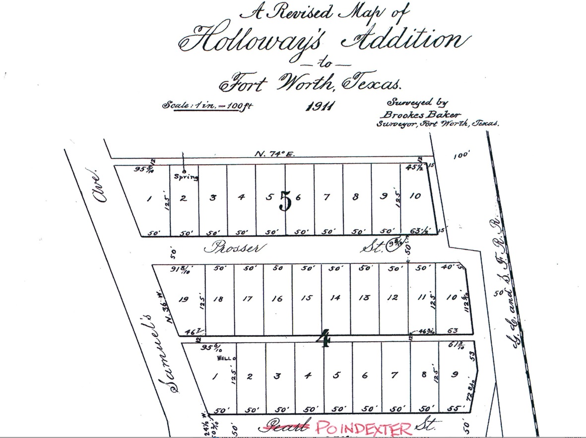
1911 subdivision map showing approximate location of probable Terry Spring at the north end of Lot 2, Block 5:
- RD Milhollin and gdvanc like this
#118
-

- Members
-
- 5,949 posts
Skyscraper Member
- Gender:Male
- Location:Fort Worth, TX
Posted 01 September 2022 - 07:46 PM
#119
-
- Members
-
- 5,949 posts
Skyscraper Member
- Gender:Male
- Location:Fort Worth, TX
#120
-
- Moderators
-
- 2,280 posts
Skyscraper Member
- Gender:Male
- Location:Downtown Fort Worth
Posted 02 September 2022 - 12:47 PM
I've never walked into the site but I'm pretty sure it is south of the former railroad spur and east of the electric transformer.
- Stadtplan likes this
#121
-
- Members
-
- 5,949 posts
Skyscraper Member
- Gender:Male
- Location:Fort Worth, TX
Posted 23 December 2022 - 11:22 AM
https://www.tdlr.tex.../TABS2023008299


1 user(s) are reading this topic
0 members, 1 guests, 0 anonymous users

