This abandoned bridge spanned the West Fork of the Trinity on the old Handley Ederville Road just north of Randol Mill Road 1/2 mile west of Loop 820. The present river channel in that area has been moved, straightened and levees built on both sides.
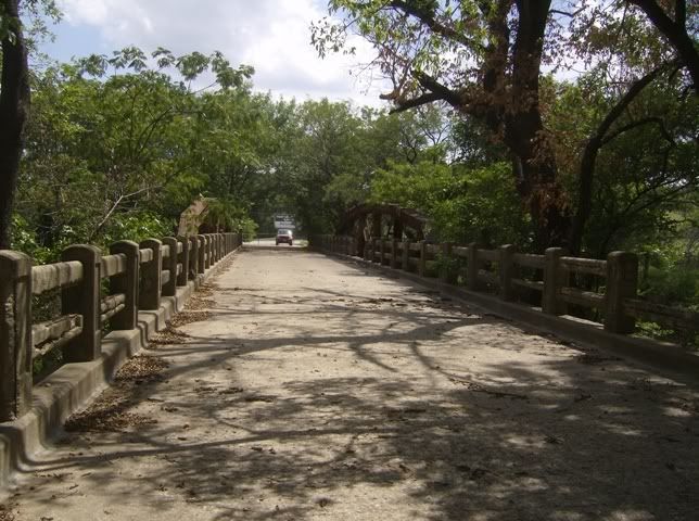
The bridge appears to have been built as a triple span steel girder with concrete siderails and curbs and is typical of ca 1910-30 construction. The center span appears to have been reinforced with steel pony trusses mounted outboard on new piers. Those pony trusses are typical of bridges from the 1870s and later and I suspect were salvaged from another location rather than being original to the bridge.
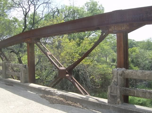
Does anyone recall the bridge before the trusses were added and/or when that happened?
The bridge was superseded by the present Handley Ederville Road Bridge and Bridgewood Drive. The old Handley Ederville Road south of Randol Mill Road was displaced by the Loop 820 construction in the early 1960s, but a 1979 map shows the old bridge and old Handley Ederville Road north of Randol Mill Road for a half mile or so still in use. Present Handley Ederville Road north from the new bridge is the same as it was pre Loop 820. Does anyone recall when the new bridge was constructed and the river channelized?
Mosier Lake, which is just northeast of the new bridge and extends under Loop 820, was also the original West Fork channel. It was mined for sand and gravel before its present recreational use. Does anyone have a timeline on that?
M C Toyer
I was born in 1966 and grew up on the East Side, and the trusses have been on the bridge for as long as I can remember. My dad worked for Bell Helicopter, and when I was a little kid we only had one car, so my mom would drive my dad to work & then take us to school everyday. We always took Randol Mill to Precinct Line to Hwy 10 as our route to Bell, so I remember that bridge well, & the similar one (without trusses) that crosses the Trinity at Precinct Line a few miles east of there. The Precinct Line bridge is right by the Historical Marker for the old Randol Mill (you have to trespass in a field to read it) and the old road across the Trinity is still visible just a 20-30 yards to the west of the bridge.
I remember there were two Liquor stores right by the Handley-Ederville bridge on the south side (these closed years ago-not the Majestic/Holiday liquor stores present) and I think one of those buildings may still be there, or was the last time I was over there. That always made me wonder if Haltom City/Birdville was dry at one point and those were the nearest liquor stores.
As for Mosier Lake ( which I did not know was it's name ), the body of water on the east side of 820, which is pretty much undeveloped, has been there for as long as I can remember. The developed or "man-made" lake on the west side of 820 was created about the same time as The Newell-Newell business park I think, which would have been maybe late 70's, closer to early 80's. I know Riverbend athletic club had Tennis courts and a pavillion area down there. The present Handley-Ederville Bridge and the re-routing of the river didn't happen until the early to mid 90's.


